Monday, October 31, 2011
Ice Cream Sandwich on the Galaxy Nexus
Beaming a video with a single tap or unlocking a device with only a smile sounds like science fiction. Now, you can actually do these things (and more) with a phone that fits in the palm of your hand.
Wednesday morning in Hong Kong—together with Samsung—we unveiled Galaxy Nexus, the first phone designed for the latest release of Android 4.0, also known as Ice Cream Sandwich.
With a super slim profile, Galaxy Nexus features a 4.65” Contour Display with true high definition (720p) resolution and a lightning-fast dual core 1.2ghz processor combined with 4G LTE or HSPA+ technology. Galaxy Nexus also features the latest in software: Ice Cream Sandwich makes Android simple and beautiful, and takes the smartphone to beyond smart.
Beauty and simplicity
With Ice Cream Sandwich, our mission was to build a mobile OS that works on both phones and tablets, and to make the power of Android enticing and intuitive. We created a new font that’s optimized for HD displays and eliminated all hardware buttons in favor of adaptable software buttons. We also dramatically improved the keyboard, made notifications more interactive and created resizable widgets.
The desktop-class browser is significantly faster, featuring a refined tab manager and the ability to sync your bookmarks with Google Chrome. Ice Cream Sandwich also features the best mobile Gmail experience to date, with a new design that lets you quickly swipe through your inbox and search messages even when you’re offline. Calendar boasts a clean new look and you can zoom into your schedule with a pinch.
Connect and share
People are at the heart of Ice Cream Sandwich. We rethought how you browse your contacts with the new People app, which combines high-resolution photos and updates from Google+ and other social services. It’s also easier to capture and share your life with family and friends. Galaxy Nexus sports a high-end camera with zero shutter lag, automatic focus, top notch low-light performance and a simple way to capture panoramic pictures. Shoot amazing photos or 1080p video, and then edit and share them directly from your phone.
Beyond smart
Galaxy Nexus isn’t just a smartphone—it’s beyond smart. Ice Cream Sandwich gives you complete control over the amount of mobile data you use by helping you better understand and manage it. We’re also introducing Android Beam, which uses near field communication (NFC) to instantly share webpages, YouTube videos, maps, directions and apps by simply tapping two phones together. Face Unlock uses state-of-the-art facial recognition technology to unlock your phone with nothing more than a smile.
This weekend marks the third birthday of the G1, the first-ever Android phone. Nine releases later, more than 550,000 Android devices are activated daily.
Starting in November, Galaxy Nexus will be available in the United States, Canada, Europe and Asia. Check out the Nexus website for a product tour and more info.
Sunday, October 30, 2011
The Hunt for Treasures With Google Earth
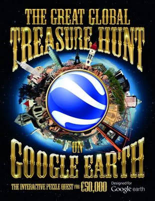
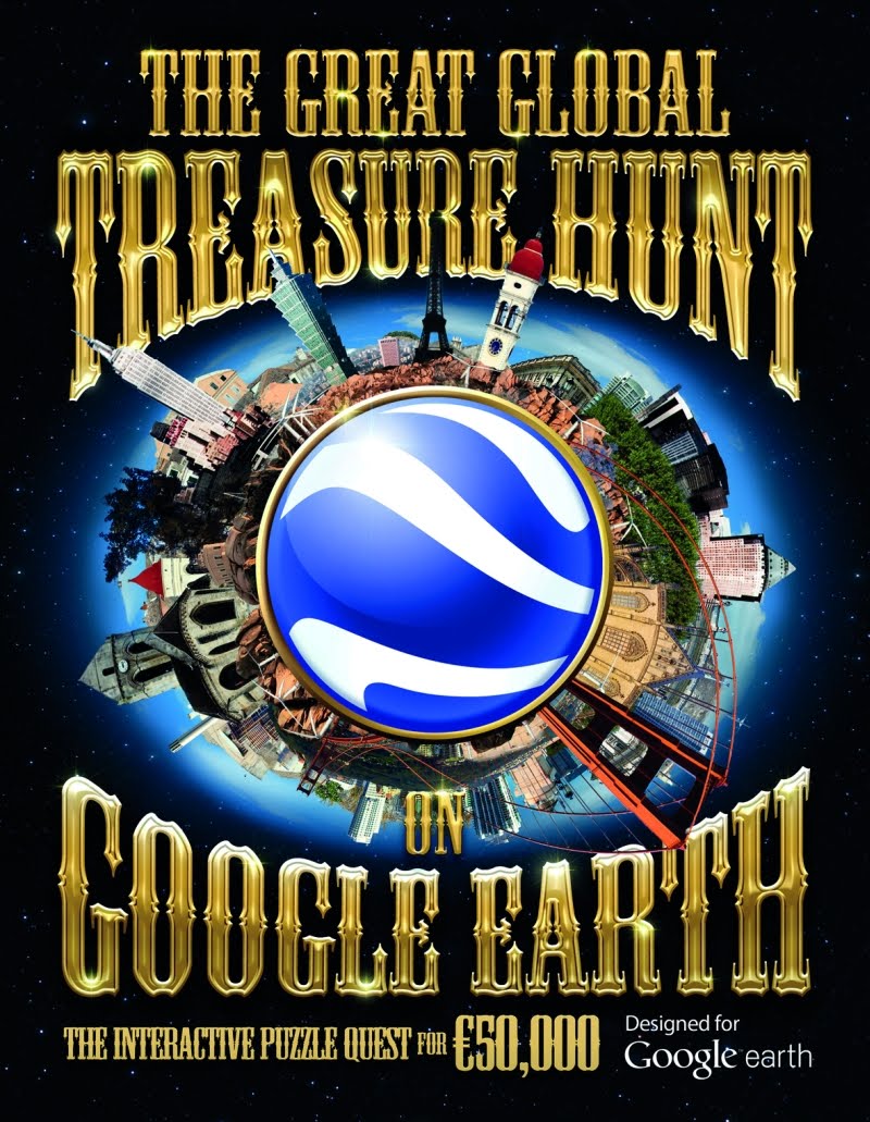
For as long as I can remember my dad has had a real knack for doing puzzles, in particular cryptic crosswords. On the other hand, I don’t have a clue when it comes to puzzles. I just don’t seem to be able to get into that “figuring out puzzles” mindset. But my time may have come with the release of a new book The Great Global Treasure Hunt on Google Earth by Carlton Books.
Filled with beautiful artwork, The Great Global Treasure Hunt allows you to take part in an interactive puzzle quest that could lead to a €50,000 prize. You can take part in a journey of discovery as the book works with Google Earth to reveal a series of textual and visual clues. Once you’ve made sense of each of these, a picture will begin to emerge leading you to a specific location on Google Earth. When you think you picked apart the clues set by the book’s puzzle master, Dedopulos, you can submit your answer online for your chance to win the €50,000 prize.
 One of Google Earth’s most notable attributes is its ability to facilitate a better understanding of the world around us. With more than 700 million activations, a new breed of “armchair explorers” with a thirst for information are using Google Earth to make new discoveries and enhance their understanding of our planet - and sometimes further afield. I’m really excited that this book uses Google Earth to add a 21st century technological twist to the world of mysteries and puzzles.
 One of Google Earth’s most notable attributes is its ability to facilitate a better understanding of the world around us. With more than 700 million activations, a new breed of “armchair explorers” with a thirst for information are using Google Earth to make new discoveries and enhance their understanding of our planet - and sometimes further afield. I’m really excited that this book uses Google Earth to add a 21st century technological twist to the world of mysteries and puzzles.
Saturday, October 29, 2011
Applications in Windows Azure
Several other people have already written on the subject of writing an Azure application that makes use of the SQL Server spatial datatypes. See, for example, Johannes Kebeck’s or Rex Hansen’s articles. However, having tried to answer a question on this subject today, I noticed that both of these articles are a little out of date, or are not quite complete. So I thought I’d summarise the current steps involved in creating and deploying an application that makes use of the geometry and geography datatypes in an Azure application, including the steps involved if you want to use the new spatial features in SQL Server Denali. Note that I’m talking about Azure here, not SQL Azure (although that too can make use of spatial datatypes) – so, this is about using the same spatial functionality as in SQL Server but in a cloud-based application layer rather than in a cloud-based database layer.
Within the C:Temp folder you should now find subfolders matching the directory structure described above each containing one of the dll files. You can check that you’ve got the right version of the files by comparing them to the details below:


 Note that, in addition to the libraries above, to make the Denali libraries work on Azure you’ll also need the msvcr100.dll and msvcp100.dll files installed in the Win/System64 directory.
This step is described in Johannes’ article (which, remember, is 2 years old). However, since v1.2 (released June 2010) every Azure web role now runs under full trust, and can run native code by default (source: MSDN). Therefore no additional configuration changes are currently required to access the spatial libraries from your Azure application.
Note that, in addition to the libraries above, to make the Denali libraries work on Azure you’ll also need the msvcr100.dll and msvcp100.dll files installed in the Win/System64 directory.
This step is described in Johannes’ article (which, remember, is 2 years old). However, since v1.2 (released June 2010) every Azure web role now runs under full trust, and can run native code by default (source: MSDN). Therefore no additional configuration changes are currently required to access the spatial libraries from your Azure application.
 2. Add a web role to the project
 3. Select Project –> Add Reference and click the Browse tab to navigate to the directory in which you unpacked the spatial libraries. Add a reference to Microsoft.SqlServer.Types.dll, which can be found in Program Files (x86)Microsoft SQL Server110SDKAssembliesMicrosoft.SqlServer.Types.dll
 4. Change the properties of the Microsoft.SqlServer.Types library to “Copy Local = True”
 5. Select Project –> Add Existing Item and navigate to the /Windows/System32 directory. Then, add the SqlServerSpatial110.dll file.
 6. Select Project –> Add Existing Item again. This time, navigate to the /Win/System64 directory and highlight both the msvcp100.dll and msvcr100.dll files.
 7. Set the properties of msvcp100.dll, msvcr.dll and SqlServerSpatial110.dll to “Copy to Output directory = Copy always”
 8. The libraries are now ready to use, so write some code that makes use of them. Here’s a silly demo just to prove that I’m making use of a Denali spatial function, BufferWithCurves(). Firstly, edit the Default.aspx file as follows:
Then edit the Default.aspx.cs file to be as follows:
9. Right-click on the Windows Azure project and select to Publish. In the following dialog, choose to Create Service Package only.
8. The libraries are now ready to use, so write some code that makes use of them. Here’s a silly demo just to prove that I’m making use of a Denali spatial function, BufferWithCurves(). Firstly, edit the Default.aspx file as follows:
Then edit the Default.aspx.cs file to be as follows:
9. Right-click on the Windows Azure project and select to Publish. In the following dialog, choose to Create Service Package only.
 10. Logon to the Windows Azure Management Portal. Create a New Hosted Service and enter the details of the service. In the Package Location and Configuration File boxes, select the .cspkg and .cscfg files created by Visual Studio in the bin/Debug/Publish directory of your project.
 11. Once the service has been created, navigate to the DNS of your new service and enjoy:

What library(s) to use?
The spatial functionality in SQL Server comes provided courtesy of two libraries:- Microsoft.SqlServer.Types.dll – this is a (managed) .NET library that is installed in the /Program Files(x86)/Microsoft SQL Server/100/SDK/Assemblies subdirectory of a SQL Server installation and is registered in the GAC of any computer on which SQL Server has been installed.
- SQLServerSpatial.dll – this is an (unmanaged) C++ library that can be found in the /Windows/System32 directory. In SQL Server Denali, the equivalent library is called SQLServerSpatial110.dll.
Getting the Libraries
If you’ve already got a 64-bit version of either SQL Server 2008 or Denali on your machine, you can use the libraries installed with it in the locations described above. If not, the easiest way to get hold of compatible libraries is to download an x64 version of the SQL Server Feature Pack. Note that you can get hold of and use these libraries from the feature pack without ever needing to install SQL Server.- You can get the Oct 2008 x64 Feature Pack for SQL Server 2008 from here.
- Or, if you want to use latest features such as support for curved geometry types, you can download the latest (CTP3) x64 Feature Pack for SQL Server Denali from here.
msiexec /a SQLSysClrTypes.msi /qb TARGETDIR="C:/Temp"
SQL Server 2008


Denali CTP3

 Note that, in addition to the libraries above, to make the Denali libraries work on Azure you’ll also need the msvcr100.dll and msvcp100.dll files installed in the Win/System64 directory.
Trust and Unmanaged Code
Prior to Windows Azure v1.2, the default trust level for Windows Azure applications was medium trust. That meant that, in order to use native unmanaged code libraries such as SqlServerSpatial.dll in an Azure application, you had to explicitly grant access by including the following property in the ServiceDefinition.csdef file:enableNativeCodeExecution="true"
Step-By-Step Guide
Having covered the points above that may have been missing from other guides, here’s a complete step-by-step guide to creating a spatial Azure application using the SQL Server Denali CTP3 spatial library. So, first of all, get hold of a copy of the 64-bit Microsoft® System CLR Types for SQL Server® code name ‘Denali’ CTP 3 from the CTP3 Feature Pack, and extract the dlls from it (or just install the .msi) as described above. All set? Then let’s go… 1. From Visual Studio 2010, create a new Windows Azure Project 2. Add a web role to the project
 3. Select Project –> Add Reference and click the Browse tab to navigate to the directory in which you unpacked the spatial libraries. Add a reference to Microsoft.SqlServer.Types.dll, which can be found in Program Files (x86)Microsoft SQL Server110SDKAssembliesMicrosoft.SqlServer.Types.dll
 4. Change the properties of the Microsoft.SqlServer.Types library to “Copy Local = True”
 5. Select Project –> Add Existing Item and navigate to the /Windows/System32 directory. Then, add the SqlServerSpatial110.dll file.
 6. Select Project –> Add Existing Item again. This time, navigate to the /Win/System64 directory and highlight both the msvcp100.dll and msvcr100.dll files.
 7. Set the properties of msvcp100.dll, msvcr.dll and SqlServerSpatial110.dll to “Copy to Output directory = Copy always”
 8. The libraries are now ready to use, so write some code that makes use of them. Here’s a silly demo just to prove that I’m making use of a Denali spatial function, BufferWithCurves(). Firstly, edit the Default.aspx file as follows:
<%@ Page Title="Home Page" Language="C#" MasterPageFile="~/Site.master" AutoEventWireup="true" CodeBehind="Default.aspx.cs" Inherits="WebRole1._Default" %>SQL Server Denali Spatial and Azure Demo
The area of a circle of radius 100 is... (uses SQL Server Denali's BufferWithCurves() method).
using System;
using System.Collections.Generic;
using System.Linq;
using System.Web;
using System.Web.UI;
using System.Web.UI.WebControls;

using Microsoft.SqlServer.Types;

namespace WebRole1
{
  public partial class _Default : System.Web.UI.Page
  {
    protected void Page_Load(object sender, EventArgs e)
    {
      Calculate_Area();
    }
    private void Calculate_Area()
    {
      SqlGeometry point = SqlGeometry.Point(0,0,0);
      SqlGeometry circle = point.BufferWithCurves(100);
      area.InnerText = circle.STArea().ToString();
    }
  }
}
 10. Logon to the Windows Azure Management Portal. Create a New Hosted Service and enter the details of the service. In the Package Location and Configuration File boxes, select the .cspkg and .cscfg files created by Visual Studio in the bin/Debug/Publish directory of your project.
 11. Once the service has been created, navigate to the DNS of your new service and enjoy:

Inside the map with Google MapsGL
You’re now one step closer to experiencing and interacting with a 3D mirror of the real world within your browser with Google MapsGL. Google MapsGL takes Google Maps and harnesses the power of Web Graphics Library (WebGL) to create far richer visuals and animations.
WebGL is a new technology that brings hardware-accelerated 3D graphics to the browser without additional installed software. With WebGL your maps experience is much better with 3D buildings, smoother transitions between imagery and the ability to instantly “swoop” into Street View without a plugin.
Starting today, if you’re using supported browsers (such as Chrome 14+ or Firefox Beta) with compatible video cards, you can opt in to the early beta release. Visit maps.google.com and click “Try it now,” or visit maps.google.com/gl to learn more.
We’ve been using WebGL to create experiences like our Chrome experiments “3 Dreams of Black” and “All is Not Lost,” which happen right in the browser. Previously, such sophisticated 3D graphics have only been possible on traditional desktop applications and have required manual installation. WebGL ushers in a whole new generation of graphics on the web, and with that, we can begin to redefine the expectations of an online map.
Check out Chrome Experiments WebGL for more WebGL-powered applications, and opt in to Google MapsGL to begin using the next generation of mapping today.
Friday, October 28, 2011
Google Maps in 40+ new domains
Here at Google our goal is to make all the world’s information accessible and useful; providing relevant local data to each country has been the heart of what motivates us on the Google Maps team.
Back in 2005 we started with one domain, .com, and now almost six years later we are happy to announce today that we are adding more than 40 new domains on Google Maps. In total we have more than 130 countries with their customized maps domains and we support 60+ user interface languages.
A Maps domain is a customized entry point to our maps, tailored for a particular country, which makes searches for places and localities in the country more efficient. For example when someone in Argentina searches for “Córdoba” we know that he probably meant the one in Argentina and not the other Córdoba in Spain.
This means that whether you are in Sri Lanka, Venezuela or Cameroon you will have now a unique domain to get directions, local information and find new favorite places.
Wednesday, October 26, 2011
Stop Worrying about the Places Automatic Updates
 Thursday’s announcement that Google Places would autmatically update Places data more quickly if Google thought they had more trusted information generated a fair bit of dismay. The words used to describe Google’s action, while occassionaly positive in nature, generally reflected fear and anger:
Unnecessary, Bugs me
Headache, Impending doom
REALLY CONCERNS ME
BACK ASSWORDS!!!!, STUPID!!!! STUPID!!!! STUPID!!!!
Clusterf***, Very dangerous
This is terrible, Absolutely scary, insane decision
Like death and taxes their is a certain inexorable nature to Google. I have noted in the past that most SMBs are from Venus and Google is from Mars and so it easy to misinterpret their intent. Sometimes you can fight the reality they have created but usually it is wasted energy. On occasion it might be worth plugging in the universal translator and trying to not just understand what the machine is saying but seeing what you can learn from it. This is one of those times.
The computational machine that is Google Places doesn’t pull data out of thin air. The data that Google has in their cluster about your business comes from someplace. In this case it is coming from a source that Google trusts more than they trust you or at least wants they trust enough to want to corroborate it with you. Whenever Google is willing to share that information with us, there are insights to be gained.
OK, you say, what can I possibly learn from Google mucking with my listing? Well lets look at a few scenarios.
1. You or your client get an email addressed to an old email address suggesting updates to a listing in an account that you forgot about.
It’s a good opportunity to figure out the password, clean out the data and delete the listing from the account. You don’t need it. If it hasn’t snuck up and bitten you yet, it will. That’s where the 8th, 9th and 10 categories are coming from as well as that photo not in your dashboard.
2. You get an email suggesting that an address from 4 years ago is the correct address.
Whoah dude! You missed changing some important citations all those years ago? Maybe you didn’t realize that they would stick around this long, maybe you just didn’t know. Get out there and whack those moles. You will end up with a stronger record and more citations, you can stop the wrong address from creating a second listing for your business at the wrong address. Maybe now you will understand why consumers are complaining about ending up on the wrong side of town.
3. Google is suggesting a change in phone number or business name to your current listing.
Hmm… what trusted source did you forget to update when you changed your name or phone number? Why aren’t ALL of your upstream listings EXACTLY the same?
You can complain, you can bemoan Google actions, you can fear what is is coming next. It won’t change much. My suggestion?
Figure out what the Google machine is trying to tell you and and go out and get it squared away. This is the way the machine talks, plug in the universal translator and get to work.
Thursday’s announcement that Google Places would autmatically update Places data more quickly if Google thought they had more trusted information generated a fair bit of dismay. The words used to describe Google’s action, while occassionaly positive in nature, generally reflected fear and anger:
Unnecessary, Bugs me
Headache, Impending doom
REALLY CONCERNS ME
BACK ASSWORDS!!!!, STUPID!!!! STUPID!!!! STUPID!!!!
Clusterf***, Very dangerous
This is terrible, Absolutely scary, insane decision
Like death and taxes their is a certain inexorable nature to Google. I have noted in the past that most SMBs are from Venus and Google is from Mars and so it easy to misinterpret their intent. Sometimes you can fight the reality they have created but usually it is wasted energy. On occasion it might be worth plugging in the universal translator and trying to not just understand what the machine is saying but seeing what you can learn from it. This is one of those times.
The computational machine that is Google Places doesn’t pull data out of thin air. The data that Google has in their cluster about your business comes from someplace. In this case it is coming from a source that Google trusts more than they trust you or at least wants they trust enough to want to corroborate it with you. Whenever Google is willing to share that information with us, there are insights to be gained.
OK, you say, what can I possibly learn from Google mucking with my listing? Well lets look at a few scenarios.
1. You or your client get an email addressed to an old email address suggesting updates to a listing in an account that you forgot about.
It’s a good opportunity to figure out the password, clean out the data and delete the listing from the account. You don’t need it. If it hasn’t snuck up and bitten you yet, it will. That’s where the 8th, 9th and 10 categories are coming from as well as that photo not in your dashboard.
2. You get an email suggesting that an address from 4 years ago is the correct address.
Whoah dude! You missed changing some important citations all those years ago? Maybe you didn’t realize that they would stick around this long, maybe you just didn’t know. Get out there and whack those moles. You will end up with a stronger record and more citations, you can stop the wrong address from creating a second listing for your business at the wrong address. Maybe now you will understand why consumers are complaining about ending up on the wrong side of town.
3. Google is suggesting a change in phone number or business name to your current listing.
Hmm… what trusted source did you forget to update when you changed your name or phone number? Why aren’t ALL of your upstream listings EXACTLY the same?
You can complain, you can bemoan Google actions, you can fear what is is coming next. It won’t change much. My suggestion?
Figure out what the Google machine is trying to tell you and and go out and get it squared away. This is the way the machine talks, plug in the universal translator and get to work.
Street View and the Swiss Alps
From the Amazon to the ancient ruins of Pompeii, Street View technology has put imagery of some of the world’s most interesting and significant sites online for everyone to enjoy. Now, for the first time in Google Maps, we’re hitting the train tracks to capture the majesty of the famous railway lines of the Swiss Alps and the surrounding scenery.
In cooperation with Rhaetian Railway, our Street View team has collected images from one of the world’s most scenic railway routes—the Albula-Bernina line in Switzerland—that will soon be live on Google Maps. The picturesque route through the Swiss Alps is one of most famous in the world, winding its way through wild mountain scenery from Thusis, Switzerland; past the resort town of St. Moritz; to its final stop just over the border in Tirano, Italy.
A complex system of tunnels, viaducts and galleries allow the railway line to pass through the narrow valleys and climb almost 2,000 meters in altitude. It’s unique to see technology and architecture like this in a natural landscape, and the route is a popular tourist destination offering amazing photography opportunities.
To capture the stunning scenery for Street View, we mounted our trike—a three-wheel pedicab with a camera system on top—to a flatbed at the front of a train. As the train travelled along the line, cameras facing nine different directions captured still photos of the surrounding areas that we’re now stitching together into 360-degree panoramic views. Soon, we’ll publish the imagery on Google Maps for people around the globe to enjoy and experience themselves. The imagery will provide admirers of this route with completely new perspectives, and also help document and preserve this UNESCO World Heritage site.
In the meantime, enjoy these photos from imagery collection day:
To get the latest on Street View go to maps.google.com/streetview.
In cooperation with Rhaetian Railway, our Street View team has collected images from one of the world’s most scenic railway routes—the Albula-Bernina line in Switzerland—that will soon be live on Google Maps. The picturesque route through the Swiss Alps is one of most famous in the world, winding its way through wild mountain scenery from Thusis, Switzerland; past the resort town of St. Moritz; to its final stop just over the border in Tirano, Italy.
View Albula-Bernina Line in a larger map
A complex system of tunnels, viaducts and galleries allow the railway line to pass through the narrow valleys and climb almost 2,000 meters in altitude. It’s unique to see technology and architecture like this in a natural landscape, and the route is a popular tourist destination offering amazing photography opportunities.
To capture the stunning scenery for Street View, we mounted our trike—a three-wheel pedicab with a camera system on top—to a flatbed at the front of a train. As the train travelled along the line, cameras facing nine different directions captured still photos of the surrounding areas that we’re now stitching together into 360-degree panoramic views. Soon, we’ll publish the imagery on Google Maps for people around the globe to enjoy and experience themselves. The imagery will provide admirers of this route with completely new perspectives, and also help document and preserve this UNESCO World Heritage site.
In the meantime, enjoy these photos from imagery collection day:
To get the latest on Street View go to maps.google.com/streetview.
Monday, October 24, 2011
Google News unique content with Editors’ Picks
News organizations tell stories online in ways that bring together the best of traditional and digital journalism, whether that involves long-form investigative features, compelling photo slideshows or interactive maps and charts that add new levels of engagement to the day's news. To help connect you to the best works of news publishers, Google News is introducing a new section in the right-hand column of the U.S. edition. The section is called "Editors' Picks,” and it displays original content that publishers have selected as highlights from their publications. This is the latest addition to recent improvements we’ve made to the variety and presence of stories and multimedia on Google News.
An array of news organizations, including local, national and niche publishers, are now using Editors’ Picks to display their best, most engaging content. Because Google News relies on algorithms, Editors' Picks will always be just that—picks provided by publishers themselves, and not by Google. You can browse a set of publisher feeds that span national, specific and local interests—like The Atlantic, The Wall Street Journal, ProPublica, the Guardian and The Root, among many others—via the side-to-side arrows next to each publisher's logo. The feeds you see are chosen based on a variety of factors, including your news preferences. If you’re interested in using source preferences on Google News, Editors' Picks helps you do that with the slider that appears just below the articles.
 You may have first noticed Editors’ Picks as an experiment last year. Based on the data from that experiment, we have been working with nearly two dozen publishers in recent months and have seen a positive response from readers and publishers alike: readers get the news they're interested in from the sources they trust, and publishers receive higher traffic to their websites. We encourage any news organizations that are interested to visit our Help Center to get started.

Sunday, October 23, 2011
Adapting AdWords for small businesses
In early 2010, I was talking with some friends from Google’s India office about how to help small, local businesses advertise online. We found that small business owners the world over had a key commonality: very little time. We decided to tackle this problem head on, with the hopes of making the advertising process quicker and easier for small businesses.
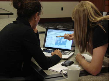
My colleagues in India flew out to our headquarters in California, and we teamed up with a Google Maps product manager who had some first hand experience working with small business owners. One of his friends ran a small mountain clothing store in New Hampshire called The Mountain Goat of Hanover, which had just moved to town. She was responsible for staffing, bookkeeping, inventory management and many other time-intensive tasks—all with very little help. She had the desire to try promoting her business online, but learning to manage a new form of advertising wasn’t something she had time for.


Kendra Dynok, manager of The Mountain Goat of Hanover, helps a customer.
The Mountain Goat of Hanover was our first case study, but it seemed like any interaction we had with a small business led to a conversation about how it advertised. A photographer in Virginia, a San Francisco dentist and a contractor re-doing my kitchen all told the same story: Online advertising should be simpler.
What all of these business owners needed was advertising that was measurable, affordable and quick. While they could use AdWords, they needed something even faster: a tool that they could set up easily and then walk away from, trusting that their advertising would be managed efficiently.
A handful of us started building a new tool for advertisers that met these requirements and within a few weeks, we were beta testing it with the owner of The Mountain Goat, the photographer, the dentist and the contractor—inviting more small businesses as interest grew. We literally went door to door in San Francisco and Chicago, asking local businesses if our tool could help them advertise better. Soon, we had more than 50 businesses testing the new ads product and within a few months, that number was over 2,000.
Our team runs somewhat like the small businesses with which we work. We’re a small, close-knit group of friends that spend most of our time huddled in a room making decisions on the spot and moving fast to launch a product in a matter of months. By the end of 2010, we’d launched our tool, which we called Google Boost at the time, in 25 cities across five states. And just last week, we officially launched AdWords Express to all businesses in the U.S. We would never have been able to do that outside of Google, where we were able to leverage the existing AdWords system, infrastructure and dedicated teams. By making it easier for people to implement effective advertising campaigns, we’ve been able to bring tens of thousands of small businesses online—and we’ve only just begun.
Saturday, October 22, 2011
Storm Tracker Beta
Met Office - Storm Tracker Beta
 The Met Office has created a new Google Maps Flash Map to monitor and forecast tropical storms around the world.
There are two versions of this map - Free and Premium (Paid For)
Free Version
· 1 x forecast weather layer (UK deterministic 5 day storm track)
· 1 x observed track
· 3 x latest weather layers:
· cloud (IR and Visible satellite)
· sea surface temperatures
· Thousands of historic storms (HURDAT data from 1850 until the present).
Advanced version (paid for service)
Additional premium content for an advanced service is available at a subscription rate.
The advanced service includes access to all the above, plus:
· Probabilistic forecasts of storms and weather – so a range of possible scenarios
can be understood
· Met Office 15 day ensemble forecast storm tracks; and equivalent data from
European Centre for Medium-range Weather Forecasting (ECMWF) and USA’s
National Oceanic and Atmospheric Administration (NOAA).
· Multi-model combinations of these leading models
· Additional forecasts for storms, including strike probabilities, forming storms, and
ensemble mean storm tracks
· A utilities layer showing district boundaries for the Gulf of Mexico
Access to these features enables users to build a far more complete picture
Users require to have an account (even for the free version) worldwide cloud conditions and the locations of current cyclones. If you select a cyclone on the map you can view the cyclone's observed track and wind speeds recorded along the track.
As well as viewing current tropical storm conditions it is also possible to view historical storm information. For example you can view the track of the 2009 Hurricane Bill.
The Met Office has created a new Google Maps Flash Map to monitor and forecast tropical storms around the world.
There are two versions of this map - Free and Premium (Paid For)
Free Version
· 1 x forecast weather layer (UK deterministic 5 day storm track)
· 1 x observed track
· 3 x latest weather layers:
· cloud (IR and Visible satellite)
· sea surface temperatures
· Thousands of historic storms (HURDAT data from 1850 until the present).
Advanced version (paid for service)
Additional premium content for an advanced service is available at a subscription rate.
The advanced service includes access to all the above, plus:
· Probabilistic forecasts of storms and weather – so a range of possible scenarios
can be understood
· Met Office 15 day ensemble forecast storm tracks; and equivalent data from
European Centre for Medium-range Weather Forecasting (ECMWF) and USA’s
National Oceanic and Atmospheric Administration (NOAA).
· Multi-model combinations of these leading models
· Additional forecasts for storms, including strike probabilities, forming storms, and
ensemble mean storm tracks
· A utilities layer showing district boundaries for the Gulf of Mexico
Access to these features enables users to build a far more complete picture
Users require to have an account (even for the free version) worldwide cloud conditions and the locations of current cyclones. If you select a cyclone on the map you can view the cyclone's observed track and wind speeds recorded along the track.
As well as viewing current tropical storm conditions it is also possible to view historical storm information. For example you can view the track of the 2009 Hurricane Bill.
 Storm Tracker Worldwide Map by the UK Met Office.
http://www.metoffice.gov.uk/premium/stormtracker/
(sign up and login required to view both free and premium)
Storm Tracker Worldwide Map by the UK Met Office.
http://www.metoffice.gov.uk/premium/stormtracker/
(sign up and login required to view both free and premium)
Help your friends switch to Gmail
I switched to Gmail the first month it came out, mere seconds after receiving an invitation from a friend and two years before joining Google. Since then, I’ve invited hundreds of people, most of whom have happily made the switch to Gmail and never looked back.
But I have one friend, Andy, who’s the straggler in the group. A couple months ago, I sent out an email about a barbecue I was having. On the “To:” line, there were 15 Gmail addresses and then Andy. He stuck out like a sore thumb. Shortly thereafter, Andy was complaining to us about how much spam he got. That was the last straw.
My friends and I sat Andy down and talked him through how to import his contacts. We answered his questions, guilt-tripped him a little, and a few painless minutes later we were done. Andy had Gmail.
We all have a story like this. On the Gmail team, we affectionately refer to them as “email interventions.” We hear about them all the time: the cousin who finally switched from an embarassing address like hottie6elliot1977 to a more professional elliot.d.smith@gmail.com, a co-worker who helped his dentist switch after he heard her grumble about having to pay for IMAP access, etc.
It’s for these folks we created emailintervention.com, a site that makes it easier than ever to help your friends and family make the switch.
Staging an intervention is simple:

- Visit emailintervention.com
- Sign in and automatically identify who from your contacts has yet to make the switch, or just enter a friend’s email address manually
- Choose from one of three intervention message templates (“straightforward”, “concerned” or “ embarrassed”), and add your own intervention video if you’d like
- Send a customized email and follow up as needed

Friday, October 21, 2011
3D Buildings - Google Maps
3D Buildings - Google Maps Expands Coverage
 Only 2.5D on the Google Maps sites (transparency induced)
But becomes true 3D on the Mobile device:
Only 2.5D on the Google Maps sites (transparency induced)
But becomes true 3D on the Mobile device:
 3D London and Paris on the Google Maps Mobile - gives users a more realistic sense of location and bearing.
Now, 3D buildings are available in London, Paris, Barcelona, Stockholm, Singapore, Lisbon, Boulder, and 11 major cities in South Africa. These buildings will appear in both Google Maps and Google Maps for mobile.
3D London and Paris on the Google Maps Mobile - gives users a more realistic sense of location and bearing.
Now, 3D buildings are available in London, Paris, Barcelona, Stockholm, Singapore, Lisbon, Boulder, and 11 major cities in South Africa. These buildings will appear in both Google Maps and Google Maps for mobile.
 Only 2.5D on the Google Maps sites (transparency induced)
But becomes true 3D on the Mobile device:
3D London and Paris on the Google Maps Mobile - gives users a more realistic sense of location and bearing.
Now, 3D buildings are available in London, Paris, Barcelona, Stockholm, Singapore, Lisbon, Boulder, and 11 major cities in South Africa. These buildings will appear in both Google Maps and Google Maps for mobile.
Only 2.5D on the Google Maps sites (transparency induced)
But becomes true 3D on the Mobile device:
3D London and Paris on the Google Maps Mobile - gives users a more realistic sense of location and bearing.
Now, 3D buildings are available in London, Paris, Barcelona, Stockholm, Singapore, Lisbon, Boulder, and 11 major cities in South Africa. These buildings will appear in both Google Maps and Google Maps for mobile.
Thursday, October 20, 2011
Flashy Google Earth Tours
Looking at the examples of GE tours out on the web I'm struck that they often use flashy attention grabbing effects but fail to communicate their content well. However, watching this video made me pause and rethink
Intangible Value: In a very entertaining talk Rory advocates the importance of 'intangible value': its not anything real but its absolutely worth something. An example he doesn't discuss is the placebo effect, results show you can put a patient in an operating theatre, slice open their knee, wiggle some tools around inside achieving precisely nothing and the patient is likely to report a real reduction in knee pain after the un-operation. Amazing isn't it?
Chart Junk: I've always advocated the Edward Tufte approach to graphic communication, he regards anything that is not directly contributing to communication as 'Chart Junk' - anything that is there to make the tour look flash or just as decoration is getting in the way of the message and should be removed. Richard Mayer has empirical evidence showing that chart junk in educational animations (which are very similar to GE tours) has a negative effect on teaching efficiency which he calls the coherence principle.
Context is All: So is chart junk fluff that should be removed or does it add a professional feel and grab attention in a useful way? My view is that in formal education (taught classes in schools or Unis) producing intangible value should be low priority, any clever effects in GE tours fail to grab attention by the 2nd or 3rd lecture of a course. However, in an outreach context, particularly in a setting like a kiosk in a museum, a GE tour would be vying for attention against other exhibits so special effects represent intangible value that is worth having. These two contexts are extreme points on the end of a scale and there are all sorts of other contexts inbetween them for which decisions need to be made. The key question in making such design decisions is 'do I need to grab users attention?'.
Content First, Flash Presentation Second: Despite the context discussion above I would add that even in a context where flash presentation is important authors need to be careful that the message still gets through. Its no use grabbing someones attention if you fail to then do anything with the time they then give you.
Wednesday, October 19, 2011
Historypin Worldwide
Historypin WorldWide Launched

The Successfully UK London Launch in 2010 has now expanded worldwide.
Last year Historypin was beta in London. The historical photographs overlayed on Google Maps StreetView become very popular. Now officially launched with a new mobile applications and worldwide coverage. "Historypin is a way for millions of people to come together, from across different generations, cultures and places, to share small glimpses of the past and to build up the huge story of human history. Everyone has history to share: whether its sitting in yellowed albums in the attic, collected in piles of crackly tapes, conserved in the 1000s of archives all over the world or passed down in memories and old stories. Each of these pieces of history finds a home on Historypin, where everyone has the chance to see it, add to it, learn from it, debate it and use it to build up a more complete understanding of the world." http://www.historypin.com/Tuesday, October 18, 2011
Google Research – Benefits of Google Earth Tours
It is always nice to announce good news. Back in February, together with [Muki Haklay at UCL], I submitted an application to the Google’s Faculty Research Award program for a grant to investigate Google Earth Tours in education. We were successful in getting a grant worth $86,883 USD. The project builds on Muki's expertise in usability studies of geospatial technologies, including the use of eye tracking and other usability engineering techniques for GIS and my expertise in Google Earth tours and education, and longstanding interest in usability issues.
Job Offer: In this joint UCL/Southampton project, UCL will be lead partner and we will appoint a junior researcher for a year to develop run experiments that will help us in understanding of the effectiveness of Google Earth Tours in geographical learning, and we aim to come up with guidelines to their use. If you are interested, get in contact with Muki.
Our main contact at Google for the project is Ed Parsons. We were also helped by Tina Ornduff and Sean Askay who acted as referees for the proposal.
The core question that we want to address is “How can Google Earth Tours be used create an effective learning experience?”
So what do we plan to do? Previous research on Google Earth Tours (GETs) has shown them to be an effective visualization technique for teaching geographical concepts, yet their use in this way is essentially passive. Active learning is a successful educational approach where student activity is combined with instruction to enhance learning. In the proposal we suggest that there is great education value in combining the advantages of the rich visualization of GETs with student activities. Evaluating the effectiveness of this combination is the purpose of the project, and we plan to do this by creating educational materials that consist of GETs and activities and testing them against other versions of the materials using student tests, eye tracking and questionnaires as data gathering techniques.
We believe that by improving the techniques by which spatial data is visualized we are improving spatial information access overall.
Related Project: A nice aspect of the getting the project funded is that it works well with a project that is led by Claire Ellul and Kate Jones and funded by JISC. The G3 project, or “Bridging the Gaps between the GeoWeb and GIS” is touching on similar aspects and we surely going to share knowledge with them.
Monday, October 17, 2011
Bing Maps Interactive SDK (AJAX 7,0)
Bing Maps Interactive SDK (AJAX 7.0)
 New Features:
 New Features:
- Create map with map options > Map with inertia intensity: Try varying the inertiaIntensity parameter in the source code window. Set it anywhere between 0 and 1, hit run, and then see what happens when you click and drag the map.
- Create map with map options > Map with background color: Pull the fully zoomed out map down to see the background color and hit the "Run" button. This shows off the new backgroundColor option and gives you a random color every time. Try typing in your own RGB values and see what you get.
- Get user location > Get location: If the browser on your phone or PC supports the W3C GeoLocation API, then try out the new getCurrentPosition method to easily find yourself on the map. (Note that the accuracy of this function varies depending on the capabilities of the requesting client. For example, desktop users may see lower accuracy while mobile users see much higher.)
- Loading dynamic module > Load module - clustering: This shows you how you can use the new module loading methods to register and load your own custom modules (or modules built by other Bing Maps developers).
Wednesday, October 12, 2011
Google Earth: Over one billion downloads
Google Earth has just hit a major milestone -- one billion downloads. Wow!
In celebration of that, Google has created a great video highlighting some of the things you can do with Google Earth:
To show some of the ways that people have used Google Earth over the past six years, Google has compiled some of their stories and put them up on OneWorldManyStories.com for you to explore.
In addition, they built a great infographic showing off many of the features that you'll find in Google Earth.
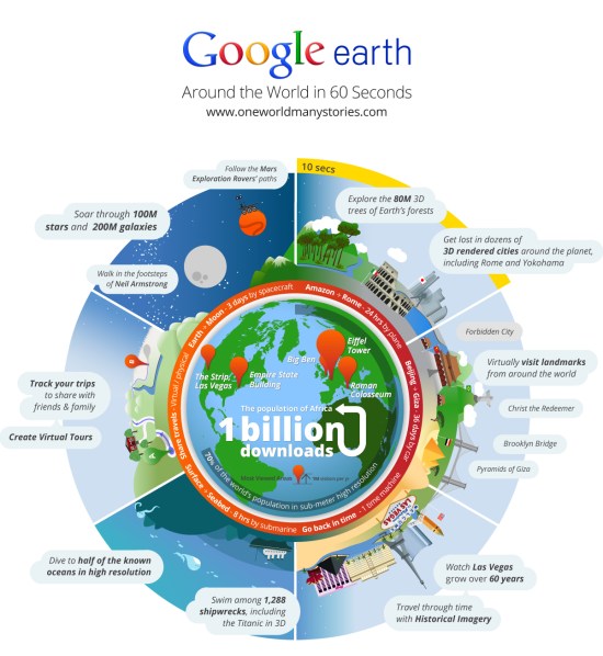 Included in the graphic:
• Explore the 80M 3D trees of Earth's forests (introduced with Google Earth 6)
• Get lost in dozens of 3D rendered cities around the planet, as well as monuments such as Christ the Redeemer, the Brooklyn Bridge and the Pyramids of Giza
• Travel through time with Historical Imagery
• Swim among 1,288 shipwrecks, including the Titanic in 3D.
• Dive to half of the known oceans in high resolution
• Create virtual tours
• Walk in the footsteps of Neil Armstrong
• Soar through 100M stars and 200M galaxies
• Follow the Mars Exploration Rovers' paths
Included in the graphic:
• Explore the 80M 3D trees of Earth's forests (introduced with Google Earth 6)
• Get lost in dozens of 3D rendered cities around the planet, as well as monuments such as Christ the Redeemer, the Brooklyn Bridge and the Pyramids of Giza
• Travel through time with Historical Imagery
• Swim among 1,288 shipwrecks, including the Titanic in 3D.
• Dive to half of the known oceans in high resolution
• Create virtual tours
• Walk in the footsteps of Neil Armstrong
• Soar through 100M stars and 200M galaxies
• Follow the Mars Exploration Rovers' paths
Outreach and Canadian mapping tools
Last week Google Earth Outreach launched our program in Canada, offering support to non-profits and aboriginal communities that wish to leverage Google’s mapping tools to improve understanding of critical issues facing Canada today. Our team spent the week in Vancouver inspiring and empowering these groups to spread their message through geographic visualizations.
 Google Earth Outreach team member Tanya Birch works with a participant on Fusion Tables.
We kicked off the week with a 3-day workshop co-hosted with our partner Tides Canada. With their help, we were able to gather developers, communications and technology professionals from over 50 organizations to be trained on Google Earth, Google Maps and Google Fusion Tables. We met folks from a diverse set of organizations, such as Ecotrust Canada, Social Alterations, Living Oceans Society, and Inuit Tapiriit Kanatami.
These groups came into the workshop with varying levels of familiarity with Google’s geo tools. While some participants leveraged the time to master the basics, others focused on advanced coding using the Maps APIs. Non-profits developed and worked on their project ideas with Earth Outreach staff on hand for guidance and technical help. Our team was amazed by some of the projects that came out of these sessions, including a Google Fusion Table map of Inuit communities and a Google Earth tour of the path of a migrating whooping crane.
Our activities in Vancouver culminated in an event on Wednesday for the wider Vancouver non-profit community. We were honored to have David Suzuki, an influential Canadian scientist, author, broadcaster and co-founder of the David Suzuki Foundation, on hand to share his thoughts on how philanthropy, public engagement and technology can advance the reach, scope and impact of Canadian civil society. Our team’s founder, Rebecca Moore, also took the stage to demonstrate how the rich variety of environmental and social issues in Canada can benefit from geographic visualizations as powerful tools for environmental advocacy and social justice. Afterwards, our team got to interact with the community face-to-face at demo stations featuring Google Earth, Google Maps, Google Fusion Tables, Open Data Kit as well as already developed Canadian mapping projects.
Google Earth Outreach team member Tanya Birch works with a participant on Fusion Tables.
We kicked off the week with a 3-day workshop co-hosted with our partner Tides Canada. With their help, we were able to gather developers, communications and technology professionals from over 50 organizations to be trained on Google Earth, Google Maps and Google Fusion Tables. We met folks from a diverse set of organizations, such as Ecotrust Canada, Social Alterations, Living Oceans Society, and Inuit Tapiriit Kanatami.
These groups came into the workshop with varying levels of familiarity with Google’s geo tools. While some participants leveraged the time to master the basics, others focused on advanced coding using the Maps APIs. Non-profits developed and worked on their project ideas with Earth Outreach staff on hand for guidance and technical help. Our team was amazed by some of the projects that came out of these sessions, including a Google Fusion Table map of Inuit communities and a Google Earth tour of the path of a migrating whooping crane.
Our activities in Vancouver culminated in an event on Wednesday for the wider Vancouver non-profit community. We were honored to have David Suzuki, an influential Canadian scientist, author, broadcaster and co-founder of the David Suzuki Foundation, on hand to share his thoughts on how philanthropy, public engagement and technology can advance the reach, scope and impact of Canadian civil society. Our team’s founder, Rebecca Moore, also took the stage to demonstrate how the rich variety of environmental and social issues in Canada can benefit from geographic visualizations as powerful tools for environmental advocacy and social justice. Afterwards, our team got to interact with the community face-to-face at demo stations featuring Google Earth, Google Maps, Google Fusion Tables, Open Data Kit as well as already developed Canadian mapping projects.
Tuesday, October 11, 2011
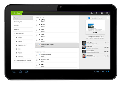
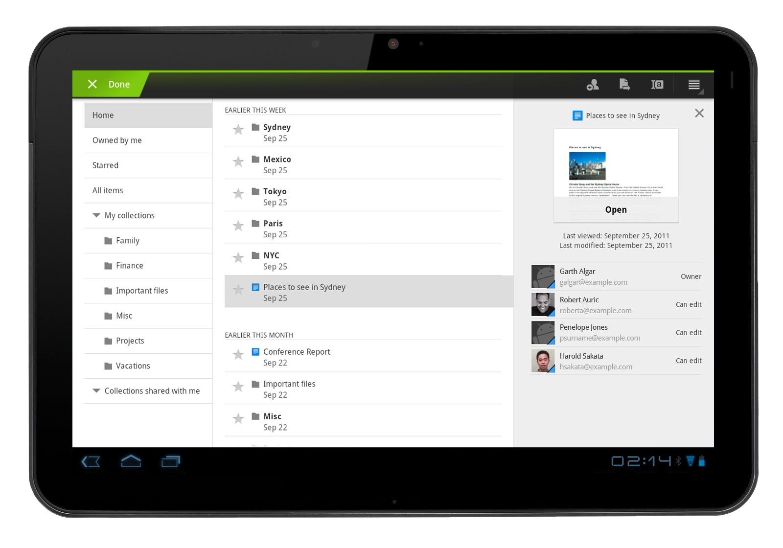
Better Google Docs experience on Android tablets
Earlier this year, we introduced the Google Docs app for Android. Since then, many users have downloaded the app and enjoyed the benefits of being able to access, edit and share docs on the go.
Today’s update to the app makes Google Docs work better than ever on your tablet. With an entirely new design, we’ve customized the look to make the most of the larger screen space on tablets. The layout includes a three-panel view, which allows you to navigate through filters and collections, view your document list, and see document details, all at once.
Looking at the details panel on the right side, you can see a thumbnail to preview a document and its details before opening it. From the panel, you can see who can view or edit any doc.
 These features are now available in 46 languages on tablet devices with Android 3.0+ (Honeycomb) and above.
You can download the app from the Android Market and let us know what you think in the comments or by posting on the forum. Learn more by visiting the help center.
These features are now available in 46 languages on tablet devices with Android 3.0+ (Honeycomb) and above.
You can download the app from the Android Market and let us know what you think in the comments or by posting on the forum. Learn more by visiting the help center.
New 3-panel view for improved browsing
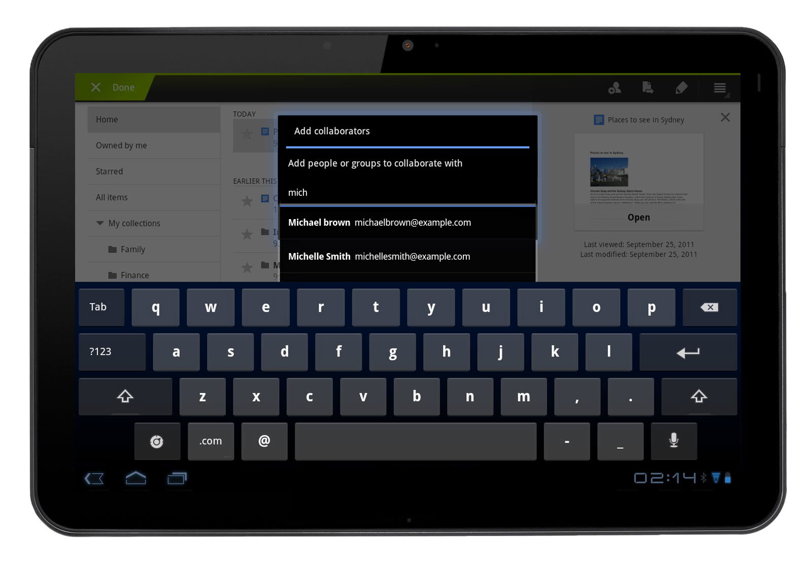 Autocomplete makes sharing with others on the go even easier
Google Places Quality Guidelines Update
The driving class that meets at the local club, the AA meeting at the local church, the Yoga class that meets at community centers, the Lamaz birthing class that meets at the medical center, the farmer’s market at the Mall parking lot…even if independently owned and operated are now explicitly prohibited from having a Places page.
Does the rule make sense? Certainly these types of businesses fall into a grey area and have long been a problem in Google Places. Is Google Places about a Place or about a business?
Given that Google has long contended that Places is supposed to be about a place then I suppose the rule has a logic to it. It is the same logic that would dictate a computer service organization that makes regular visits to the local university should not claim the university as an address.
That being said it points out another hole in Google’s ability to service this whole category of business. Google’s suggestion to leverage the Place page of the location where a class is held to mention your event makes little sense, particularly since the Place page has become much more sparse. The only real opportunity to highlight a service like this on the location’s Place page would be the “Share an update feature”. Unfortunately that is as buried as the coupon feature. Using the now hidden extra details as Google suggests would be useless and there is not enough space in the 200 character description. Not a helpful suggestion at all.
The other question that comes up is how is this sort of business different than a container business (ie an independent eye glass store that is located within a Walmart)? I think that Google would contend that the container business has a permanent presence and physical infrastructure reflecting their brand where the mobile class does not.
While I feel for the sort of business that is affected by this decision, on average I agree with it and look forward to Google developing a better way for a business that operates like this to present themselves.
Saturday, October 8, 2011
A Free Tool to Build GEO Sitemap and Schema.org Compliant Files
There are two simple ways of telling Google and the other search engines where your business is located via your website. One is to create a KML file and an attendant geo-sitemap. The other is to provide your full business contact information in rich snippet format on the site. Now there is a way to easily do both with one simple creation tool from Michael Borgelt of 51Blocks.
From a single input of your basic NAP + web information, the tool creates a kml file, a geo-sitemap file pointing Google to the KML file and an HTML code snippet in the new schema.org format for your business contact info.
You then paste the code snippet onto your contact us page or into the footer of your website, place the kml & geo-sitemap files in your public html file of your site and then reference the geo-sitemap file from the Google webmaster tools. The KML file can also be uploaded to Google MyMaps to create an embeddable direction and location map for your website.
I doubt that Google needs both signals to trust your site but by doing both you have future proofed your site for any eventuality.
Thursday, October 6, 2011
Google Earth: Tracking Tuna across the Atlantic
Tracking the patterns of Bluefin Tuna in the Atlantic Ocean might not sound too exciting, but the use of Google Earth in showing their patterns makes it quite interesting.
Eduardo Garcia-Milagros with Encyclopedia of Life has put together some great information about these Tuna.
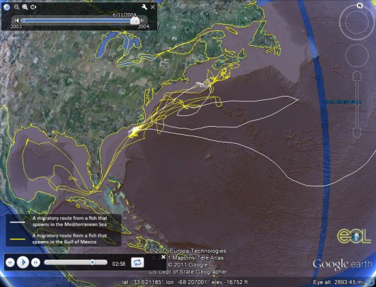 In particular, they've put together an excellent KMZ tour that shows what they're tracking, why they're tracking it, and the results of what they've discovered so far.
You can learn more at the eol's Atlantic Bluefin Tuna podcast.
In particular, they've put together an excellent KMZ tour that shows what they're tracking, why they're tracking it, and the results of what they've discovered so far.
You can learn more at the eol's Atlantic Bluefin Tuna podcast.
In particular, they've put together an excellent KMZ tour that shows what they're tracking, why they're tracking it, and the results of what they've discovered so far.
You can learn more at the eol's Atlantic Bluefin Tuna podcast.
The Planefinder.net app
Now, thanks to Planefinder.net and some clever technology, you can watch planes taking off and landing at almost any airport in the world, also those travelling across the globe - all day long, in real time and without leaving the house.
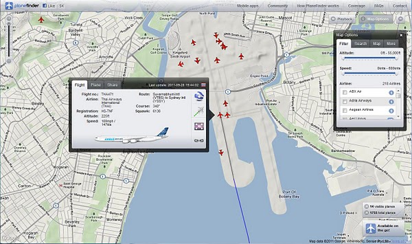 There is also an extensive range of information available on the site about individual planes and their flight details. Flight paths can be downloaded as a KML and/or shared via Twitter and Facebook. And if I miss some action, I can play back a whole day's worth of flights. The playback option allows users to select a date, the number of hours they wish to view and even the speed of the animation. Just try zooming out on the USA, set the time to 23 hours and the speed to 120x and watch. You guessed it, available for all types of smart phones as well.
There is also an extensive range of information available on the site about individual planes and their flight details. Flight paths can be downloaded as a KML and/or shared via Twitter and Facebook. And if I miss some action, I can play back a whole day's worth of flights. The playback option allows users to select a date, the number of hours they wish to view and even the speed of the animation. Just try zooming out on the USA, set the time to 23 hours and the speed to 120x and watch. You guessed it, available for all types of smart phones as well.
Sunday, October 2, 2011
Subscribe to:
Posts (Atom)