The
Google Earth and
Maps Imagery team recently published another batch of aerial and satellite imagery. In this post, we’ll focus on U.S. cities and locales, as the largest amount of new high resolution aerial imagery covers regions in the United States.
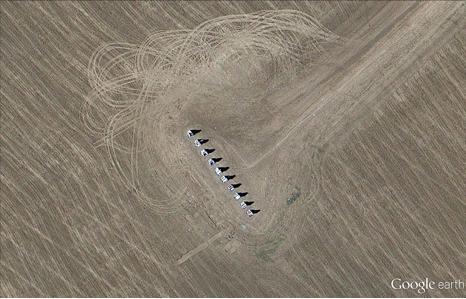
High on the list of things associated with the United States are over-sized automobile tail fins. Our first aerial image shown below is of
Cadillac Ranch, located near Amarillo, Texas. The series of partly buried and tilted Cadillacs is a public art homage to the iconic American auto.
Cadillac Ranch, Texas
Our next example is of
Downtown New Haven, Connecticut. The image shows the center park square of New Haven Green, which is surrounded by eight squares of the same size that comprise a nine-square downtown area that was first drawn out in 1638, and represents the first planned city in the United States.
Downtown New Haven, Connecticut
Few U.S. rivers are more well-known than the mighty Mississippi. The aerial image below, snapped last month, shows a portion of the river’s northern extent where it forms Saint Anthony Falls in Minneapolis, Minnesota. The Metrodome Stadium, home of the NFL franchise Minnesota Vikings, can be seen in the lower left corner. The team has played its last game there and is about to sign a 30-year deal to build a new downtown stadium.
Section of Downtown Minneapolis, Minnesota
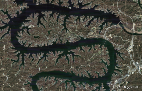
The final example shown below is a section of the “Magic Dragon,” more commonly known as the
Lake of the Ozarks. This sinuous man-made reservoir was formed by the damming of the Osage River in South-Central Missouri. More than 70,000 residences line the shoreline and the Bagnell Dam can be seen in the upper-right corner of the image.
Section of Lake of the Ozarks, Missouri
If you’d like to receive an email notification when the Google Earth and Maps Imagery team updates your favorite areas(s), we’ve got just the tool: The
Follow Your World application!
These are only a few examples of the sites that can be seen and discovered in our latest batch of published imagery. Happy exploring!
High resolution aerial updates:
U.S. cities: Big Lake, TX; Bowie, TX; Bridgeport, CT; Cleveland, OH; Danville, VA; Dickinson, ND; Farmington, MO; Grand Forks, ND; Hartford, CT; Minneapolis, MN; Providence, RI; Quincy, IL; Richlands, VA; Traverse City, MI; Youngstown, OH
Countries/regions receiving high resolution satellite updates:
Albania, Algeria, Angola, Antarctica, Argentina, Armenia, Australia, Austria, Azerbaijan, Belarus, Belize, Bolivia, Bosnia and Herzegovina, Botswana, Brazil, Bulgaria, Burkina Faso, Cambodia, Cameroon, Canada, Chad, Chile, China, Colombia, Costa Rica, Cuba, Cyprus, Côte d'Ivoire, Democratic Republic of the Congo, Denmark, Dominican Republic, Egypt, El Salvador, Equatorial Guinea, Eritrea, Estonia, Ethiopia, Fiji, France, French Polynesia, Gabon, Georgia, Germany, Ghana, Greece, Guatemala, Guinea, Guinea-Bissau, Haiti, Honduras, Iceland, India, Indonesia, Iran, Ireland, Italy, Jamaica, Japan, Kazakhstan, Kenya, Kuwait, Latvia, Lebanon, Lesotho, Libya, Madagascar, Malawi, Malaysia, Maldives, Mali, Mauritania, Mexico, Mongolia, Morocco, Mozambique, Myanmar, Namibia, Nepal, New Caledonia, New Zealand, Niger, Nigeria, North Korea, Norway, Oman, Pakistan, Panama, Papua New Guinea, Paraguay, Peru, Philippines, Poland, Portugal, Qatar, Romania, Russia, Saudi Arabia, Senegal, Serbia, Solomon Islands, Somalia, South Africa, South Korea, Spain, Sri Lanka, Sudan, Svalbard, Swaziland, Sweden, Switzerland, Syria, Tanzania, Thailand, Turkey, Uganda, Ukraine, United Arab Emirates, United States, Uruguay, Uzbekistan, Vanuatu, Venezuela, Vietnam, Western Sahara, Yemen, Zambia, Zimbabwe
These updates are now available in both Google Maps and Google Earth. For a complete picture of where we updated imagery, download
this KML for viewing in
Google Earth.
 So the iOS map app is really old and busted and this is not exactly news. I’m guessing Lead Dog and Urban Mapping will be along for the ride as well as OpenStreetMap. Apple will probably blend many data sources like their iOS iPhone maps, rather than buy wholesale from Navteq or TomTom.
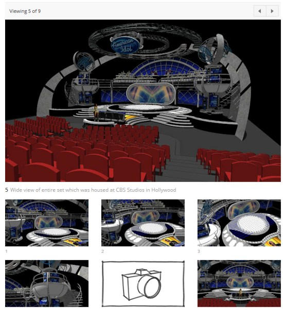 The Showcase highlights excellent Sketchup projects from around the world, and included in this site is a brand new online 3D model viewer. It allows you to orbit, zoom and pan 3D models, so you can view them from any angle without leaving your browser. Look for the little red flag icon, or click here to see the models that have this feature. It's quite slick.
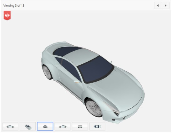 If you have a project that you feel is worthy of inclusion in the SketchUp Showcase, you can submit it for consideration here.


 Their claim of having served 20,000 clients, while an abuse of Google’s guideline against tag lines in the business name, is an interesting one. Linda Buquet pointed out one of their recent PR releases where they claim to have a current client base of more than 8,000 small business owners. The article notes that they were founded in 2010 (although their website notes a start date of 2007 and the domain was claimed in 2008).
If we take their most recent word at face value (Tough I know but..) and assume (for the sake of simple calculation) a May 2010 founding we can get a sense of their churn. They have lost 6000 customers a year. It would appear that they have lost 1.5 clients for each one still claimed to be under contract.
Still curious I wanted to see who actually owned the building that they show on their website as their presumed location so I typed their address into Google Maps to look at the Streetview of their location.
OOOPS. Turns out they violated another Places guideline and claimed their listing at the local UPS Store. The address, 2233 West Balboa Blvd # 115, Newport Beach, is the same one used in their Whois record and their website. This was no accident.
Their claim of having served 20,000 clients, while an abuse of Google’s guideline against tag lines in the business name, is an interesting one. Linda Buquet pointed out one of their recent PR releases where they claim to have a current client base of more than 8,000 small business owners. The article notes that they were founded in 2010 (although their website notes a start date of 2007 and the domain was claimed in 2008).
If we take their most recent word at face value (Tough I know but..) and assume (for the sake of simple calculation) a May 2010 founding we can get a sense of their churn. They have lost 6000 customers a year. It would appear that they have lost 1.5 clients for each one still claimed to be under contract.
Still curious I wanted to see who actually owned the building that they show on their website as their presumed location so I typed their address into Google Maps to look at the Streetview of their location.
OOOPS. Turns out they violated another Places guideline and claimed their listing at the local UPS Store. The address, 2233 West Balboa Blvd # 115, Newport Beach, is the same one used in their Whois record and their website. This was no accident.
 Still not convinced about 29Prime’s ethical behaviors? The image of their HQ on their website appeared to have been photoshopped so I dropped it into Google image search to see what I found.
Surprise! They seemed to be “occupying” the Unisys offices at 9701 Jeronimo RD Irvine, Ca. They may in fact be at that location occupying some space but the building most definitely isn’t labeled as 29Prime and they are but a renter. Hmm, stranger and stranger.
To any client of 29Prime: If these folks can’t get their own marketing story straight, how can you expect that they will get yours straight? They are obviously violating Google Places guidelines, run the risk of being suspended, are gathering fake reviews and are photoshopping images on their website that have one intention, to imply that they are more successful than they really are. Their churn rate is at best disturbing. They are willing to “cut corners” (to say the least) on their own marketing, can you really trust them with yours? Or will your listing end up suspended like theirs is likely to be?
Just for the record here is the image from the website and an unretouched image of the same location reflecting the actual occupant. It appears that they didn’t even take the time to take an original photograph and just used the one from the Wikipedia article on Unisys. They did appear to have adjusted the colors.
How many corners can one company cut?
Still not convinced about 29Prime’s ethical behaviors? The image of their HQ on their website appeared to have been photoshopped so I dropped it into Google image search to see what I found.
Surprise! They seemed to be “occupying” the Unisys offices at 9701 Jeronimo RD Irvine, Ca. They may in fact be at that location occupying some space but the building most definitely isn’t labeled as 29Prime and they are but a renter. Hmm, stranger and stranger.
To any client of 29Prime: If these folks can’t get their own marketing story straight, how can you expect that they will get yours straight? They are obviously violating Google Places guidelines, run the risk of being suspended, are gathering fake reviews and are photoshopping images on their website that have one intention, to imply that they are more successful than they really are. Their churn rate is at best disturbing. They are willing to “cut corners” (to say the least) on their own marketing, can you really trust them with yours? Or will your listing end up suspended like theirs is likely to be?
Just for the record here is the image from the website and an unretouched image of the same location reflecting the actual occupant. It appears that they didn’t even take the time to take an original photograph and just used the one from the Wikipedia article on Unisys. They did appear to have adjusted the colors.
How many corners can one company cut?


