Sunday, July 8, 2012
Public transit routing and layer in the Google Maps API
Google Maps API now enables developers to add Transit data, including public transit directions, to their maps and apps.
Whether you're planning a trip from your computer or on the spur of the moment from your mobile device, Google Maps helps you find directions in more than 475 regions around the world. Today we're pleased to announce that public transit directions are now available in the Google Maps API.
Public transit has been one of the most requested features by Maps API developers, and you can now use it in both the Google Maps Javascript v3 and the Directions Web Service. It's simple for you to update your apps to also offer routing by public transit in addition to driving, bicycling, and walking. The transit route responses include the number of stops, direction of travel and more. It will also tell you what type of vehicle you will be travelling on. Everything from a typical subway train to a funicular!
To support the launch of routing by public transit we're also adding the Transit Layer to the Maps API. For example if you are a retail chain, the Transit Layer allows you to show all the bus major transit lines that run past each store. The Transit Layer can be displayed by enabling the TransitLayer(), it’s as simple as that!
If you're using a Google Map, you can now use the Directions API web service to add this useful and helpful transit data to your map. As always, if you have any questions about public transit in the Google Maps API, we recommend posting to our sponsored tag on Stack Overflow, or if you’re at Google I/O swing by at the Google Maps Developer Sandbox.
Sunday, June 24, 2012
Explore historic sites with the World Wonders Project
I’ve always been fascinated by famous historic and cultural sites from around the world. When I was a child, flipping through encyclopedias while researching for school projects, the thought of exploring these sites was a distant dream. With the new Google World Wonders Project, that dream is now a little closer for students and others around the globe.
The World Wonders Project enables you to discover 132 historic sites from 18 countries, including Stonehenge, the archaeological areas of Pompeii and the ancient Kyoto temples. In addition to man-made sites, you can explore natural places: wander the sandy dunes of Australia’s Shark Bay or gaze up at the rock domes of Yosemite National Park in California.
World Wonders uses Street View technology to take you on a virtual trip to each iconic site. Most could not be filmed by car, so we used camera-carrying trikes to pedal our way close enough. The site also includes 3D models and YouTube videos of the historical places, so you can dig in and get more information and a broader view of each site. We also partnered with several prestigious organizations, including UNESCO, the World Monuments Fund, Getty Images and Ourplace, who provided official information and photographs for many of the sites.
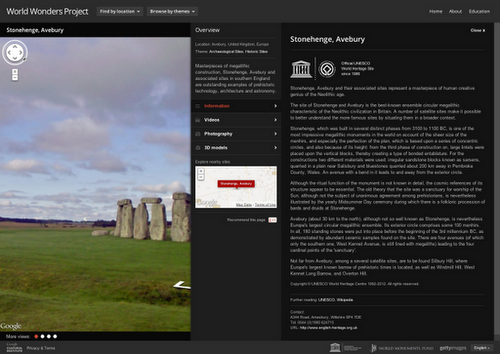 We hope World Wonders will prove to be a valuable educational resource for students and scholars. A selection of educational packages are available to download for classroom use; you can also share the site content with friends.
World Wonders is part of our commitment to preserving culture online and making it accessible to everyone. Under the auspices of the Google Cultural Institute, we’re publishing high resolution images of the Dead Sea Scrolls, digitizing the archives of famous figures such as Nelson Mandela and presenting thousands of artworks through the Art Project.
We hope World Wonders will prove to be a valuable educational resource for students and scholars. A selection of educational packages are available to download for classroom use; you can also share the site content with friends.
World Wonders is part of our commitment to preserving culture online and making it accessible to everyone. Under the auspices of the Google Cultural Institute, we’re publishing high resolution images of the Dead Sea Scrolls, digitizing the archives of famous figures such as Nelson Mandela and presenting thousands of artworks through the Art Project.
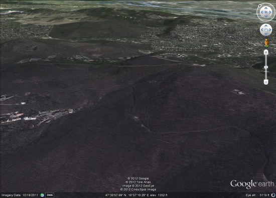
New Google Earth Imagery - May
Two weeks after their previous update, it appears that Google has just pushed out some more fresh imagery to Google Earth. Thanks to 'hhgygy' for letting us know about it!
 As is almost always the case, you can use Google Maps to determine for sure whether or not a specific area is fresh. This new imagery isn't in Google Maps yet, so you can compare Earth vs. Maps to see what's new; the fresh imagery is already in Google Earth, but the old imagery is still in Google Maps. If you compare the two side-by-side and they're not identical, that means that you've found a freshly updated area in Google Earth!
So far it appear to be a rather small update, and the imagery seems to be rather dark, but see if you can find any other updated areas.
[UPDATED - May 30, 2012 -- 10:33am EST]
As is almost always the case, you can use Google Maps to determine for sure whether or not a specific area is fresh. This new imagery isn't in Google Maps yet, so you can compare Earth vs. Maps to see what's new; the fresh imagery is already in Google Earth, but the old imagery is still in Google Maps. If you compare the two side-by-side and they're not identical, that means that you've found a freshly updated area in Google Earth!
So far it appear to be a rather small update, and the imagery seems to be rather dark, but see if you can find any other updated areas.
[UPDATED - May 30, 2012 -- 10:33am EST]
- Greece: Athens, Heraklion, Matala, Viannos, Zakynthos -- thanks 'Andreas'
- Hungary: Budapest (just west of the city)
Tuesday, June 19, 2012
Change to Review Presentation on the Places Page
Google has changed the date information attached to a review and switched from the actual date created to a rough estimate of when it was created. The actual date is still visible if you click through to the reviewer. The change seems to create a greater visual sense of whether reviews are coming in over time.
Now if they would just fix the problem of losing reviews. I find it amazing that Google is continuing to release new local products without fixing underlying issues like the problems they have keeping track of reviews and their lack of transparency in fighting review spam…

Google Earth on mobile devices
Every week, the Google Maps team hosts "office hours" -- a streamed Hangout on Google+ where you can ask the team questions and learn more about what they're working on. Their latest installment featured Josh Livni and Peter Birch, and covered quite a bit about Google Earth. They discussed the history of Google Earth, the history of Earth on mobile, and some of the directions for the future.
 They also referenced Paul van Dinther's excellent work to bring the "Perpetual Ocean" into Google Earth, which was certainly an excellent animation.
Now, thanks to the new "Hangouts On Air" feature that can stream and record Google+ Hangouts, the entire 30 minute video is available for you to view. If you're interested in the current state of affairs of Google Earth and Google Maps, it's a great video to watch.
If you'd like to join them live in the future, stay in touch via the +Google Maps API page on Google+. While you're out there, be sure to add +Google Earth Blog to your circles as well!
They also referenced Paul van Dinther's excellent work to bring the "Perpetual Ocean" into Google Earth, which was certainly an excellent animation.
Now, thanks to the new "Hangouts On Air" feature that can stream and record Google+ Hangouts, the entire 30 minute video is available for you to view. If you're interested in the current state of affairs of Google Earth and Google Maps, it's a great video to watch.
If you'd like to join them live in the future, stay in touch via the +Google Maps API page on Google+. While you're out there, be sure to add +Google Earth Blog to your circles as well!
Wednesday, June 6, 2012
Street View drives the Indianapolis Motor Speedway
Growing up in Indiana, my Dad and I shared a love of racing. Not just any kind of racing, but open-wheeled Indy Car racing. Every Memorial Day weekend, we'd get up early and drive from our home in Columbus to the Indianapolis Motor Speedway to watch our favorite spectacle in racing: the Indianapolis 500.
I went to college in Indiana as well, and we were able to keep up the tradition. But when I moved to California, we just weren't able to make it work, and we haven’t been able to attend a race together since.
Luckily, now, I’m an Engineer on Google Street View, and so I’m sure you can imagine my excitement to let the world know that the Indianapolis Motor Speedway is now available through Street View.
Once, Dad managed to get some pit passes, and we wandered around the pits and garages before the race watching the final preparation on the cars, the mechanics scurrying to have everything ready and the drivers doing their pre-race routine. It was really cool and now that's on Street View, also.
From Jim Nabors’ opening song, to the finish line and the milk, this Memorial Day, you’ll find me watching the Indy 500 with my Dad. Explore the track in Street View now and then enjoy the race with us.
Appeals Court Upholds $150K in Punitive Damages for 3 Fake Reviews
Eric Goldman of te Technology & Marketing Law reports out a recent Missouri Supreme Court ruling that upheld a jury award of $150,00 against an ex-partner that wrote 3 fake reviews on Yahoo & Google about his former business. The ruling should cause competitors leaving fake reviews to take note as it substantially eases the burden on the defamed business to not have to demonstrate direct losses (which is impossible on the interent).
Hosto and Mitchell formed two companies together. Eventually, the relationship soured, and they acrimoniously split their empire. Still grousy, Hosto (pretending to be former customers) posted three fake derogatory Google and Yahoo reviews of the company operated by Mitchell. After a John Doe lawsuit, Yahoo disclosed enough information to identify Hosto as the author, and Hosto confessed to the vendetta. Thus, we have the unusual situation where a pseudonymous review author isn’t contesting authorship. After a trial, the jury ruled in favor of Fireworks Restoration’s (the plaintiff’s) defamation claim.
 So far, everything makes sense. But then we get to the remedies, and things get puzzling. The jury awarded $1 in compensatory damages and $150k in punitive damages. On appeal, the court rejects Hosto’s attempts to undermine the jury award: that Mitchell’s company didn’t suffer any reputational harm; that Missouri law doesn’t allow nominal damages; and that the punitive damages were unconstitutionally large in light of the compensatory damages award. As a result, the jury verdict stands.
What to make of this jury verdict? One way to interpret it is that the jury felt that the company suffered no real harm, but Hosto’s behavior was so outrageous it needed to be punished anyway. While the jury’s first conclusion might seem initially counterintuitive, it’s entirely possible that the company suffered no actual harm from the negative fake reviews. Research indicates that a few negative reviews mixed into an otherwise all-positive review set lifts sales conversion because the negative reviews increase the credibility of the positive reviews and help prospective consumers visualize and assess the possible bad outcomes from their wrong choices. Without more detail, for all we know, Hosto could have done his target a favor.
Yet, the judge refuses to put the burden on the plaintiff to find actual lost customers:
So far, everything makes sense. But then we get to the remedies, and things get puzzling. The jury awarded $1 in compensatory damages and $150k in punitive damages. On appeal, the court rejects Hosto’s attempts to undermine the jury award: that Mitchell’s company didn’t suffer any reputational harm; that Missouri law doesn’t allow nominal damages; and that the punitive damages were unconstitutionally large in light of the compensatory damages award. As a result, the jury verdict stands.
What to make of this jury verdict? One way to interpret it is that the jury felt that the company suffered no real harm, but Hosto’s behavior was so outrageous it needed to be punished anyway. While the jury’s first conclusion might seem initially counterintuitive, it’s entirely possible that the company suffered no actual harm from the negative fake reviews. Research indicates that a few negative reviews mixed into an otherwise all-positive review set lifts sales conversion because the negative reviews increase the credibility of the positive reviews and help prospective consumers visualize and assess the possible bad outcomes from their wrong choices. Without more detail, for all we know, Hosto could have done his target a favor.
Yet, the judge refuses to put the burden on the plaintiff to find actual lost customers:
We reject Defendant’s contention that Plaintiff needed to produce testimony from potential customers who opted to turn elsewhere due to the web reviews. With the internet, consumers are able to compare businesses and their wares with unprecedented speed. Interpersonal contact is characteristically absent, so if a consumer declines to engage a business it encounters on the internet, that consumer continues his or her search and the business has no knowledge it has been passed by. As such, it would be unreasonably burdensome to impose upon a business plaintiff the requirement that it locate potential customers that it never knew in order to successfully demonstrate actual damage to its reputation. The deleterious impact of such a constraint far outweighs any benefits it would have in proving reputational harm.In the end, the lesson from this case is obvious and hardly novel: fake competitive reviews are a bad idea. The jury verdict here shows that the jury will punish anyone caught red-handed. At the same time, the jury was quite savvy about the compensatory damages from fake negative reviews. I hope future judges will be equally savvy.
Wednesday, May 30, 2012
An Easier Way to Analyze, Plan and Explore
Hey there, Garmin runners, cyclists, triathletes and fitness fanatics. This is a quick note to tell you about some new changes to the navigation within Garmin Connect. Once logged into your account, you'll notice that we have simplified the navigation tabs with four categories:
 all your past activities including metrics of each), reports
- Dashboard
- Analyze
Sunday, May 27, 2012
Follow an email’s journey with Story of Send
If you’re anything like me, you send and receive a lot of emails every day. But have you ever wondered where your message goes after you hit “send?” How does an email travel from your computer to your friend’s smartphone across the country or around the world?
We’re answering those questions with Story of Send, a new site that gives you a behind-the-scenes look into how all that virtual information makes its journey through the real world—from your Internet service provider to our data centers and beyond. Along the way, you’ll discover everything from where we filter for spam and scan for viruses to how we’re minimizing our impact on the environment through energy efficiency and renewable power.
We’ve included videos and photos throughout the journey so you can explore certain areas more deeply. For example, if you’re curious what data center servers look like, we’ve included some photos. Or you can watch a video to learn about how we purchase clean energy from wind farms near our data centers. And because technology doesn’t always have to be serious, you might find a vampire or two lurking around or uncover other surprises on the journey.
In the past, Gmail fans have shown us how emails connect people across the world. Now we’re providing a glimpse into how those emails go from one place to another. So hit send and start the journey today.
Friday, May 25, 2012
Possible Data Sources in Apple's iOS Map
So what do you do on a Friday morning when an editor tells you to get some “exclusive” Apple news on the front page. Clearly this:
 So the iOS map app is really old and busted and this is not exactly news. I’m guessing Lead Dog and Urban Mapping will be along for the ride as well as OpenStreetMap. Apple will probably blend many data sources like their iOS iPhone maps, rather than buy wholesale from Navteq or TomTom.
According to trusted sources, Apple has an incredible headline feature in development for iOS 6: a completely in-house maps application. Apple will drop the Google Maps program running on iOS since 2007 in favor for a new Maps app with an Apple backend.
So the iOS map app is really old and busted and this is not exactly news. I’m guessing Lead Dog and Urban Mapping will be along for the ride as well as OpenStreetMap. Apple will probably blend many data sources like their iOS iPhone maps, rather than buy wholesale from Navteq or TomTom.
Google+ for Android: polish and performance
We continue to work toward a simpler, more beautiful Google, and today we're accelerating these efforts with a new Google+ app for Android phones. The update includes lots of highly-requested features—like the ability to start a hangout on the go, and to edit posts inline—as well as a stream that celebrates the rich content shared across Google+. In all cases we're building for a mobile future, and we're excited about what's ahead.
Start a hangout from anywhere, and ring the folks that matter most
With Hangouts we want to help people connect face-to-face-to-face—at any time, from anywhere. Of course, there's really only one device that's always by your side—your phone—so we've invested in mobile hangouts since early on. Today we're adding another important feature to the mix: the ability to start a hangout directly from your mobile device.
To get started, tap “Hangout” in the (new) navigation ribbon, add some friends and tap “Start.” We'll ring their phones (if you want), and if someone misses the hangout, they can ring you back with a single tap.
Share your favorites, and feel awesome afterward
When you share with your circles, we owe you an experience that's both intimate and immersive. Your time and your relationships are precious, after all, so your posts should make you feel proud. Today's new Android app takes this to heart, with full-screen media in the stream, conversations that fade into view and instantly-touchable actions like +1.
Do more, in less time
We think you’ll find today’s app nicer to look at, but we’re also making it easier to use. Improvements include:
- A navigation ribbon that slides in and out, providing quick access to just about everything
- The ability to download photos directly from Google+, and turn them into wallpaper
- The chance to edit posts inline, in case you make any mistakes while on the go
Thursday, May 24, 2012
The best SketchUp projects in the new SketchUp Showcase
I've long said that 3D models are one of my favorite aspects of Google Earth. From cities to universities to cathedrals to even my own house, I love exploring the 3D world of Google Earth.
The tool behind these great models, of course, is Google SketchUp. SketchUp is an amazing (free!) software tool to allow you create 3D models, and you can view thousands of those models in the Google 3D Warehouse. Now they have a new tool to make it even easier to find excellent 3D models -- the new SketchUp Showcase.
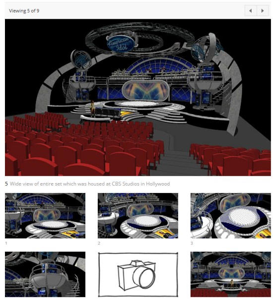 The Showcase highlights excellent Sketchup projects from around the world, and included in this site is a brand new online 3D model viewer. It allows you to orbit, zoom and pan 3D models, so you can view them from any angle without leaving your browser. Look for the little red flag icon, or click here to see the models that have this feature. It's quite slick.
 If you have a project that you feel is worthy of inclusion in the SketchUp Showcase, you can submit it for consideration here.
The Showcase highlights excellent Sketchup projects from around the world, and included in this site is a brand new online 3D model viewer. It allows you to orbit, zoom and pan 3D models, so you can view them from any angle without leaving your browser. Look for the little red flag icon, or click here to see the models that have this feature. It's quite slick.
If you have a project that you feel is worthy of inclusion in the SketchUp Showcase, you can submit it for consideration here.
Wednesday, May 23, 2012
Google Earth Imagery Update May 14
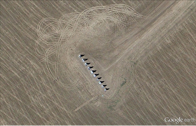
The Google Earth and Maps Imagery team recently published another batch of aerial and satellite imagery. In this post, we’ll focus on U.S. cities and locales, as the largest amount of new high resolution aerial imagery covers regions in the United States.
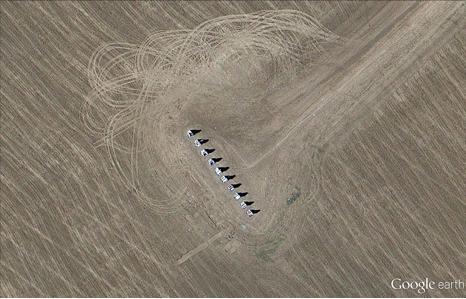
High on the list of things associated with the United States are over-sized automobile tail fins. Our first aerial image shown below is of Cadillac Ranch, located near Amarillo, Texas. The series of partly buried and tilted Cadillacs is a public art homage to the iconic American auto.
 Cadillac Ranch, Texas
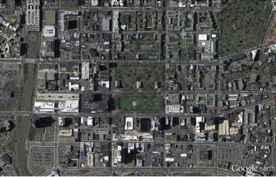
Our next example is of Downtown New Haven, Connecticut. The image shows the center park square of New Haven Green, which is surrounded by eight squares of the same size that comprise a nine-square downtown area that was first drawn out in 1638, and represents the first planned city in the United States.
Cadillac Ranch, Texas
Our next example is of Downtown New Haven, Connecticut. The image shows the center park square of New Haven Green, which is surrounded by eight squares of the same size that comprise a nine-square downtown area that was first drawn out in 1638, and represents the first planned city in the United States.
 Downtown New Haven, Connecticut
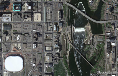
Few U.S. rivers are more well-known than the mighty Mississippi. The aerial image below, snapped last month, shows a portion of the river’s northern extent where it forms Saint Anthony Falls in Minneapolis, Minnesota. The Metrodome Stadium, home of the NFL franchise Minnesota Vikings, can be seen in the lower left corner. The team has played its last game there and is about to sign a 30-year deal to build a new downtown stadium.
Downtown New Haven, Connecticut
Few U.S. rivers are more well-known than the mighty Mississippi. The aerial image below, snapped last month, shows a portion of the river’s northern extent where it forms Saint Anthony Falls in Minneapolis, Minnesota. The Metrodome Stadium, home of the NFL franchise Minnesota Vikings, can be seen in the lower left corner. The team has played its last game there and is about to sign a 30-year deal to build a new downtown stadium.
 Section of Downtown Minneapolis, Minnesota
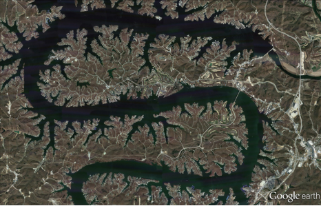
The final example shown below is a section of the “Magic Dragon,” more commonly known as the Lake of the Ozarks. This sinuous man-made reservoir was formed by the damming of the Osage River in South-Central Missouri. More than 70,000 residences line the shoreline and the Bagnell Dam can be seen in the upper-right corner of the image.
Section of Downtown Minneapolis, Minnesota
The final example shown below is a section of the “Magic Dragon,” more commonly known as the Lake of the Ozarks. This sinuous man-made reservoir was formed by the damming of the Osage River in South-Central Missouri. More than 70,000 residences line the shoreline and the Bagnell Dam can be seen in the upper-right corner of the image.
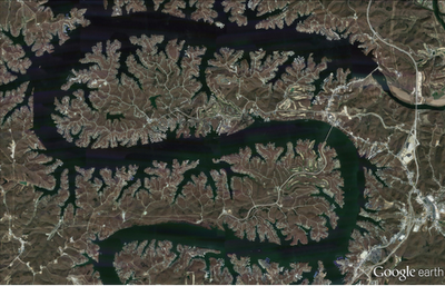 Section of Lake of the Ozarks, Missouri
If you’d like to receive an email notification when the Google Earth and Maps Imagery team updates your favorite areas(s), we’ve got just the tool: The Follow Your World application!
These are only a few examples of the sites that can be seen and discovered in our latest batch of published imagery. Happy exploring!
High resolution aerial updates:
U.S. cities: Big Lake, TX; Bowie, TX; Bridgeport, CT; Cleveland, OH; Danville, VA; Dickinson, ND; Farmington, MO; Grand Forks, ND; Hartford, CT; Minneapolis, MN; Providence, RI; Quincy, IL; Richlands, VA; Traverse City, MI; Youngstown, OH
Countries/regions receiving high resolution satellite updates:
Albania, Algeria, Angola, Antarctica, Argentina, Armenia, Australia, Austria, Azerbaijan, Belarus, Belize, Bolivia, Bosnia and Herzegovina, Botswana, Brazil, Bulgaria, Burkina Faso, Cambodia, Cameroon, Canada, Chad, Chile, China, Colombia, Costa Rica, Cuba, Cyprus, Côte d'Ivoire, Democratic Republic of the Congo, Denmark, Dominican Republic, Egypt, El Salvador, Equatorial Guinea, Eritrea, Estonia, Ethiopia, Fiji, France, French Polynesia, Gabon, Georgia, Germany, Ghana, Greece, Guatemala, Guinea, Guinea-Bissau, Haiti, Honduras, Iceland, India, Indonesia, Iran, Ireland, Italy, Jamaica, Japan, Kazakhstan, Kenya, Kuwait, Latvia, Lebanon, Lesotho, Libya, Madagascar, Malawi, Malaysia, Maldives, Mali, Mauritania, Mexico, Mongolia, Morocco, Mozambique, Myanmar, Namibia, Nepal, New Caledonia, New Zealand, Niger, Nigeria, North Korea, Norway, Oman, Pakistan, Panama, Papua New Guinea, Paraguay, Peru, Philippines, Poland, Portugal, Qatar, Romania, Russia, Saudi Arabia, Senegal, Serbia, Solomon Islands, Somalia, South Africa, South Korea, Spain, Sri Lanka, Sudan, Svalbard, Swaziland, Sweden, Switzerland, Syria, Tanzania, Thailand, Turkey, Uganda, Ukraine, United Arab Emirates, United States, Uruguay, Uzbekistan, Vanuatu, Venezuela, Vietnam, Western Sahara, Yemen, Zambia, Zimbabwe
These updates are now available in both Google Maps and Google Earth. For a complete picture of where we updated imagery, download this KML for viewing in Google Earth.
Section of Lake of the Ozarks, Missouri
If you’d like to receive an email notification when the Google Earth and Maps Imagery team updates your favorite areas(s), we’ve got just the tool: The Follow Your World application!
These are only a few examples of the sites that can be seen and discovered in our latest batch of published imagery. Happy exploring!
High resolution aerial updates:
U.S. cities: Big Lake, TX; Bowie, TX; Bridgeport, CT; Cleveland, OH; Danville, VA; Dickinson, ND; Farmington, MO; Grand Forks, ND; Hartford, CT; Minneapolis, MN; Providence, RI; Quincy, IL; Richlands, VA; Traverse City, MI; Youngstown, OH
Countries/regions receiving high resolution satellite updates:
Albania, Algeria, Angola, Antarctica, Argentina, Armenia, Australia, Austria, Azerbaijan, Belarus, Belize, Bolivia, Bosnia and Herzegovina, Botswana, Brazil, Bulgaria, Burkina Faso, Cambodia, Cameroon, Canada, Chad, Chile, China, Colombia, Costa Rica, Cuba, Cyprus, Côte d'Ivoire, Democratic Republic of the Congo, Denmark, Dominican Republic, Egypt, El Salvador, Equatorial Guinea, Eritrea, Estonia, Ethiopia, Fiji, France, French Polynesia, Gabon, Georgia, Germany, Ghana, Greece, Guatemala, Guinea, Guinea-Bissau, Haiti, Honduras, Iceland, India, Indonesia, Iran, Ireland, Italy, Jamaica, Japan, Kazakhstan, Kenya, Kuwait, Latvia, Lebanon, Lesotho, Libya, Madagascar, Malawi, Malaysia, Maldives, Mali, Mauritania, Mexico, Mongolia, Morocco, Mozambique, Myanmar, Namibia, Nepal, New Caledonia, New Zealand, Niger, Nigeria, North Korea, Norway, Oman, Pakistan, Panama, Papua New Guinea, Paraguay, Peru, Philippines, Poland, Portugal, Qatar, Romania, Russia, Saudi Arabia, Senegal, Serbia, Solomon Islands, Somalia, South Africa, South Korea, Spain, Sri Lanka, Sudan, Svalbard, Swaziland, Sweden, Switzerland, Syria, Tanzania, Thailand, Turkey, Uganda, Ukraine, United Arab Emirates, United States, Uruguay, Uzbekistan, Vanuatu, Venezuela, Vietnam, Western Sahara, Yemen, Zambia, Zimbabwe
These updates are now available in both Google Maps and Google Earth. For a complete picture of where we updated imagery, download this KML for viewing in Google Earth.


Would you Buy a Used Car From These Guys
This is a cautionary tale to 29Prime’s remaining 8000 clients. If this company abuses their own Google Places listing imagine what they might be doing in your name.
Let me be upfront with my bias.. 29Prime is not one of my favorite companies. And I have in the past commented on their abuse of Google Place’s reviews to hide the reality of who they really are. But reader Dave Middleton pointed out that in addition to abusing Google Places’s review policy they are also abusing the Google Places Guidelines as well by adding a tagline to their business name in their Places listing:
 Their claim of having served 20,000 clients, while an abuse of Google’s guideline against tag lines in the business name, is an interesting one. Linda Buquet pointed out one of their recent PR releases where they claim to have a current client base of more than 8,000 small business owners. The article notes that they were founded in 2010 (although their website notes a start date of 2007 and the domain was claimed in 2008).
If we take their most recent word at face value (Tough I know but..) and assume (for the sake of simple calculation) a May 2010 founding we can get a sense of their churn. They have lost 6000 customers a year. It would appear that they have lost 1.5 clients for each one still claimed to be under contract.
Still curious I wanted to see who actually owned the building that they show on their website as their presumed location so I typed their address into Google Maps to look at the Streetview of their location.
OOOPS. Turns out they violated another Places guideline and claimed their listing at the local UPS Store. The address, 2233 West Balboa Blvd # 115, Newport Beach, is the same one used in their Whois record and their website. This was no accident.
Their claim of having served 20,000 clients, while an abuse of Google’s guideline against tag lines in the business name, is an interesting one. Linda Buquet pointed out one of their recent PR releases where they claim to have a current client base of more than 8,000 small business owners. The article notes that they were founded in 2010 (although their website notes a start date of 2007 and the domain was claimed in 2008).
If we take their most recent word at face value (Tough I know but..) and assume (for the sake of simple calculation) a May 2010 founding we can get a sense of their churn. They have lost 6000 customers a year. It would appear that they have lost 1.5 clients for each one still claimed to be under contract.
Still curious I wanted to see who actually owned the building that they show on their website as their presumed location so I typed their address into Google Maps to look at the Streetview of their location.
OOOPS. Turns out they violated another Places guideline and claimed their listing at the local UPS Store. The address, 2233 West Balboa Blvd # 115, Newport Beach, is the same one used in their Whois record and their website. This was no accident.
 Still not convinced about 29Prime’s ethical behaviors? The image of their HQ on their website appeared to have been photoshopped so I dropped it into Google image search to see what I found.
Surprise! They seemed to be “occupying” the Unisys offices at 9701 Jeronimo RD Irvine, Ca. They may in fact be at that location occupying some space but the building most definitely isn’t labeled as 29Prime and they are but a renter. Hmm, stranger and stranger.
To any client of 29Prime: If these folks can’t get their own marketing story straight, how can you expect that they will get yours straight? They are obviously violating Google Places guidelines, run the risk of being suspended, are gathering fake reviews and are photoshopping images on their website that have one intention, to imply that they are more successful than they really are. Their churn rate is at best disturbing. They are willing to “cut corners” (to say the least) on their own marketing, can you really trust them with yours? Or will your listing end up suspended like theirs is likely to be?
Just for the record here is the image from the website and an unretouched image of the same location reflecting the actual occupant. It appears that they didn’t even take the time to take an original photograph and just used the one from the Wikipedia article on Unisys. They did appear to have adjusted the colors.
How many corners can one company cut?
Still not convinced about 29Prime’s ethical behaviors? The image of their HQ on their website appeared to have been photoshopped so I dropped it into Google image search to see what I found.
Surprise! They seemed to be “occupying” the Unisys offices at 9701 Jeronimo RD Irvine, Ca. They may in fact be at that location occupying some space but the building most definitely isn’t labeled as 29Prime and they are but a renter. Hmm, stranger and stranger.
To any client of 29Prime: If these folks can’t get their own marketing story straight, how can you expect that they will get yours straight? They are obviously violating Google Places guidelines, run the risk of being suspended, are gathering fake reviews and are photoshopping images on their website that have one intention, to imply that they are more successful than they really are. Their churn rate is at best disturbing. They are willing to “cut corners” (to say the least) on their own marketing, can you really trust them with yours? Or will your listing end up suspended like theirs is likely to be?
Just for the record here is the image from the website and an unretouched image of the same location reflecting the actual occupant. It appears that they didn’t even take the time to take an original photograph and just used the one from the Wikipedia article on Unisys. They did appear to have adjusted the colors.
How many corners can one company cut?
Monday, May 21, 2012
Made in NY Digital Map
Map of the Week: Made in NY Digital Map
Why we like it: A beautiful visualization of tech companies in New York City, which uses Styled Maps and our Marker Clusterer library. Also, this is the first map to come to us directly from New York City Mayor Michael Bloomberg (perhaps as a result of his pledge to learn code in 2012:)!
This week’s ‘Map of the Week’ comes to us directly from New York City Mayor Michael Bloomberg! On Tuesday at Internet Week New York, Mayor Bloomberg released Made in New York as a resource for job seekers. The map is a visualization of the city’s tech startups that connects jobs seekers with job listings.
To help users better visualize all the data on the map, Marker Clusterer is used to group together a collection of points that are in close proximity to each other. The resulting clusters are color coded by the number of listings that they contain, and a Styled Map is used to make the data stand out better.
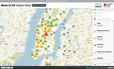 At launch Made in New York contains more than 500 companies. Of those companies, about 325 are currently hiring. You can sort the map by digital companies, investors, and co-working/incubator spaces
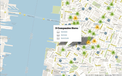 Mayor Bloomberg has high hopes for this Google Map. At the conference Bloomberg stated “We expect this map to be another tool that helps propel our tech industry forward.” With a map as beautifully designed as Made in New York, good things are sure to follow.
Sunday, May 20, 2012
The Google Places API search refinements
The Google Places API allows web and mobile app developers to search Google’s index of business listings and POI data. Since launching the Places API last year we’ve received a lot of great feedback from developers, in response to which we’ve implemented a number of additional features. Today we are taking a closer look at two of them: keyword search and rank by distance.
Keyword search
When searching for business it’s often the case that you have very fine grained requirements. You don’t just want a restaurant, you want a Mexican restaurant. You don’t just want a clothes shop, you want a vintage clothes shop. You don’t just a want a bar, you want a bar that offers live music. The Google Places API offers filtering over 100 different types, includingRank by distancerestaurant,clothing_store, andbar. As rich as this type scheme is, it can not cover the infinite range of fine grained requirements that you or your users might have. For these situations the Places API now offers keyword search, which searches places based on an arbitrary text string. Results are matched against all the information that Google has about a business, including country specific categories, cuisine, and Google review content. Keyword searches can also be combined with type filters. For example, you could add a type filter of ‘bar’ to a keyword search for ‘wine’ to ensure your search results include only drinking establishments, and not wine merchants.
By default, the Google Places API orders the search results it returns using the same ranking algorithm as Google Maps, which prioritises places that are popular or prominent. This is great for local discovery and check-in apps, as these are the places likely to be the most interesting or relevant. However for certain types of search, such as gas stations or atms, the closest result is usually preferable. To help with these use case the Places API can now rank results strictly by distance. In order to rank results by distance you must use some form of query or filter on the search. This can be a name filter, a type filter, or a keyword search. When results are ranked by distance it is not necessary to provide a search radius as the Places API will try to return the 20 closest results within reasonable distance.Keyword search and rank by distance are available in both the Places API web service and in the places library of the JavaScript Maps API v3. You can try these new features using the map below. Enter any keywords into the text field, and optionally filter over business types using the drop down menu on the right. You can also switch to ranking by distance, in which case the places closest to the center of the map (indicated by the red map pin) will be returned: These new features are a direct result of feedback from Places API developers. If you would like to help us improve the Places API further, please submit ideas for new features using the Maps API Issue Tracker. For assistance using these features, or any other aspect of the Places API, you can find us on Stack Overflow.
Saturday, May 19, 2012
Shop and travel with Google Maps 6.7 for Android - now with Google Offers and indoor walking directions
Wherever you are, Google Maps for Android helps you get around and discover new places. Today with the 6.7 release we will help you find offers from nearby businesses in the U.S. -- everything from restaurants, to salons, to city tours. Also, we’ve added indoor walking directions in the U.S. and Japan, plus 360-degree interior photos of businesses, to help you intrepidly make your way indoors and out.
Discover great offers near you
Today, in the U.S. only, we’re launching a way to discover nearby Google Offers in Google Maps for Android. To see great deals near you, tap on “Maps” to open the dropdown menu and then tap on “Offers.” If you see something you like you can click on it to learn more. Some Google Offers can be purchased and saved for later while others are immediately available for free. With free Google Offers, press “Use now” to redeem instantly or “Save for later” for future use. You can also opt-in to receive notifications in the app when there are offers near you.
Explore the great indoors with walking directions and Business Photos.
Since we launched indoor maps in the U.S. and Japan in Google Maps for Android last November, business owners have been adding their floor plans to our maps with Google Maps Floor Plans. Today, we are launching indoor walking directions for participating venues in these countries. This will help you get directions not only to a building’s front door, but also through those doors to the places where you want to go inside.


Get Indoor walking directions in indoor maps (photo: Macy’s San Francisco)
With Google Business Photos you can explore panoramic photos of the inside of a business from the palm of your hand. Now you can get a feel for a restaurant or store inside as well as outside using Street View technologies. To access these 360-degree panoramic views, look for the “See Inside” section on the Place page of select businesses.

See the interior of participating businesses with Business Photos (photo: Toyjoy)
Download Google Maps 6.7 for Android from Google Play, and use it as your trusted guide to help you find and discover places to eat, shop and play! You can also learn more about other great features on the Google Maps YouTube channel.
(Cross-posted on the Official Google Mobile Blog)
Saturday, March 24, 2012
Ideas Made Real
The Make Ideas Real project with the goal of creating a showcase of the best SketchUp work from around the world. To build out this showcase, we asked you all to share stories of how SketchUp is helping you to turn your ideas into something tangible. The response has been overwhelming.
In just one month, our launch video received nearly quarter million views and several hundred of you took the time to tell us your SketchUp story. Your positive reaction and the quality of the work you’ve shared with us is inspiring, but to truly blow out this showcase, we need to hear from even more of you.
If you haven’t yet told us your SketchUp story, share it now by filling out this form. If SketchUp has helped you turn an idea into reality, we want to hear about it.
And for your inspiration, here are just a few of the hundreds of quality submissions we’ve received so far:

 Wine Bar design by Bertier Luyt of FranceMore images (See! You can use SketchUp to build a wine bar.)

 Scout Trebuchet by Peter Leroux and friends of South AfricaMore images | 3D model | Ropes and Poles blog

 X Games Street and Park Courses by Dug Ketterman of CaliforniaDug's website

 The Machine by Evan Seccombe of CaliforniaA re-imagined prop from the film Contact, 3D printed
Voice Search in the Middle East
The launch of Voice Search in Arabic and Hebrew for Android and iPhone users.
Users in Egypt, Jordan, Kuwait, Lebanon, Qatar, UAE, and Israel can now speak Arabic and Hebrew into their phones to get search results quickly and easily. With this launch, Voice Search is now supported in 29 languages and accents in 37 countries.
When building support for Arabic and Hebrew into our language model we faced some unique challenges, including how to understand words with diacritics (accents that indicate a difference in pronunciation, a linguistic phenomenon called “Nikud” in Hebrew, and “Tashkil” in Arabic) and words appended with other words (“and” for example) that can have many different nuanced meanings.
To train our system we collected over one million utterances in Arabic and Hebrew, using the languages as they are spoken in the more populated parts of each country. For Arabic, we trained the system to recognize Gulf, Levant and Egyptian dialects. While initially we may not accurately recognize words spoken in every regional accent and dialect, one of the major benefits to Google’s cloud-based model is that the more people use Voice Search, the more accurate it becomes.
Availability
How you get started with Google Voice Search depends on what kind of phone you have. If your phone runs Android 2.2 or later, and you see the microphone icon on the Google Search widget on your homescreen, all you have to do is tap the icon to start a voice-powered search. Otherwise, you can install the Voice Search app from Android Market. Note that you can only speak one language into the app at any time and that you may need to change your language setting first.
To get Google Search App for iPhone, search for ‘Google Search App’ in the App Store or follow this link. If you already have Google Search App installed, you can enable voice search by selecting the new languages from the settings panel within the app.
Saturday, March 10, 2012
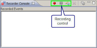
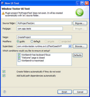
The WindowTester open source release
We are thrilled to announce the open sourcing release of WindowTester Pro, a solution that automates the process of GUI testing. WindowTester Pro is shipped as a Eclipse plugin and has support for Eclipse versions 3.5, 3.6 and 3.7. WindowTester Pro was previously offered by Instantiations Inc.
 Using WindowTester Pro, developers can easily create tests for every GUI they create. The tests generated by WindowTester Pro are standard Java JUnit tests, thus they can be run within your Eclipse environment or they can be automated to run using Ant. Tests can be generated for SWT and Swing Java applications.
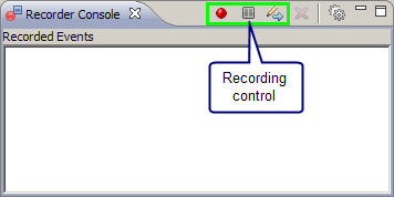
WindowTester Pro contains a recording console that captures and records keyboard clicks and mouse movements. The first step in test development is to turn on the Record feature and then work with various elements of the UI such as windows or buttons. WindowTester Pro will capture the steps taken.
Using WindowTester Pro, developers can easily create tests for every GUI they create. The tests generated by WindowTester Pro are standard Java JUnit tests, thus they can be run within your Eclipse environment or they can be automated to run using Ant. Tests can be generated for SWT and Swing Java applications.
WindowTester Pro contains a recording console that captures and records keyboard clicks and mouse movements. The first step in test development is to turn on the Record feature and then work with various elements of the UI such as windows or buttons. WindowTester Pro will capture the steps taken.
 Once the GUI has been exercised, the developer closes the application under test. When the application is closed, the recording is terminated and the test is generated.
 Using WindowTester Pro empowers developers with testing capabilities and reduces the time required to hand-code tests. This enables developers to build quality into the product early in the process because problems are found and resolved earlier in the development cycle. WindowTester Pro can help developers and companies drastically lower both testing time and cost.
For more information, please visit the WindowTester Pro home page or join the discussion list.
The Googlers who made this open sourcing release possible include Eric Clayberg, Keerti Parthasarathy, Mark Russell, and Seth Hollyman.
Using WindowTester Pro empowers developers with testing capabilities and reduces the time required to hand-code tests. This enables developers to build quality into the product early in the process because problems are found and resolved earlier in the development cycle. WindowTester Pro can help developers and companies drastically lower both testing time and cost.
For more information, please visit the WindowTester Pro home page or join the discussion list.
The Googlers who made this open sourcing release possible include Eric Clayberg, Keerti Parthasarathy, Mark Russell, and Seth Hollyman.

Using maps to help protect coral reefs
Since the early days of Google Earth, organizations have found it to be an excellent tool for tracking the status of coral reefs. Back in 2006, Frank showed you ReefBase and Reef Watch, and we've posted a variety of other stories since then. Coral Reefs cover less than 0.1% of the ocean, yet nearly 25% of all known marine species call them home, making them crucial for our oceans ecosystem.
The World Resources Institute has used Google Earth to create tours of reefs around the world to show threats them from sources such as coastal development, pollution, climate-related threats and others.
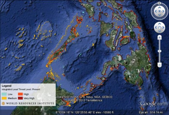 Their tours include photos and underwater video from reefs around the world. Taking it further, they also have created maps to show projected reef maps for the years 2030 and 2050. You can download this KMZ file
 to explore their current data, or grab the KMZ files for the 2030 or 2050 projects.
Their tours include photos and underwater video from reefs around the world. Taking it further, they also have created maps to show projected reef maps for the years 2030 and 2050. You can download this KMZ file to explore their current data, or grab the KMZ files for the 2030 or 2050 projects.
Monday, March 5, 2012
SketchUp: A solution for low resolution
Have you ever brought an image texture into SketchUp and notice that the resolution isn’t as crisp as it is in your image viewer?
 Notice that the image in SketchUp (Right) is not as crisp as the original image (Left)
No, you’re not seeing things. By default, SketchUp downgrades higher resolution image textures to a maximum of 1024 x 1024 pixels because in the past graphics cards didn’t have the horsepower to render models with large textures on screen reliably.
If you want to turn off this feature, you can do so by going to Properties > OpenGL, and checking the “Use maximum texture size”. With this checked, SketchUp will no longer downgrade your image textures to 1024px. SketchUp will communicate with your video card and if everything is up to snuff, your image will display at a new maximum resolution of up to 4096 x 4096 pixels.
Notice that the image in SketchUp (Right) is not as crisp as the original image (Left)
No, you’re not seeing things. By default, SketchUp downgrades higher resolution image textures to a maximum of 1024 x 1024 pixels because in the past graphics cards didn’t have the horsepower to render models with large textures on screen reliably.
If you want to turn off this feature, you can do so by going to Properties > OpenGL, and checking the “Use maximum texture size”. With this checked, SketchUp will no longer downgrade your image textures to 1024px. SketchUp will communicate with your video card and if everything is up to snuff, your image will display at a new maximum resolution of up to 4096 x 4096 pixels.
 With the “Use maximum texture size” selected, the image in SketchUp (Right) displays at a much higher resolution
Important note! Your first inclination might be to activate the “Use maximum texture size” option and bring in the highest resolution textures possible.
But as anyone well-versed in the “science” of modeling with textures will tell you, the size of images DO matter. Large textures can bloat the size of your SketchUp model and tax your video card and system memory exponentially. If you are going to use the “maximum texture” option, you will need to be extra conscious about the size of your image textures and choose which ones need to be at a higher resolution.
With the “Use maximum texture size” selected, the image in SketchUp (Right) displays at a much higher resolution
Important note! Your first inclination might be to activate the “Use maximum texture size” option and bring in the highest resolution textures possible.
But as anyone well-versed in the “science” of modeling with textures will tell you, the size of images DO matter. Large textures can bloat the size of your SketchUp model and tax your video card and system memory exponentially. If you are going to use the “maximum texture” option, you will need to be extra conscious about the size of your image textures and choose which ones need to be at a higher resolution.
New App Stats for Publishers on Android Market
If you've published an app on Android Market, you’ve probably used Application Statistics to help tune your development and marketing efforts. Application Statistics is a set of dashboards in the Developer Console that shows your app’s installation performance across key dimensions such as countries, platform versions, device models, and others. Today we are making Application Statistics even more powerful for publishers, adding new metrics, new ways to analyze your data, and a redesigned UI that’s much easier to use.
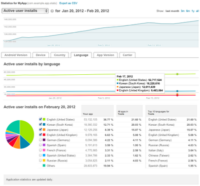 First, we are adding important new installation metrics to the dashboards. You can now see your installations measured by unique users, as well as by unique devices. For user installations, you can view active installs, total installs, and daily installs and uninstalls. For devices, you can see active installs as well as daily installs, uninstalls, and upgrades.
Along with the new metrics, we’re also introducing two new data dimensions — Carrier and App Version. You can use them to track your app’s installation trends across mobile operators or monitor the launch metrics of specific app updates.
To give you visibility over your installation data over time, we’re adding timeline charts for all metrics and dimensions. At a glance, these charts highlight your app’s installation peaks and longer-term trends, which you can correlate to promotions, app improvements, or other factors. You can even focus in on data inside a dimension by adding specific points (such as individual platform versions or languages) to the timeline.
Finally, we’re bringing you all of the new metrics, dimensions, and timelines in a completely redesigned UI that is faster, more compact, and easier to use. Each dimension is now displayed in dedicated tab, making it easier to click through your stats daily or as often as needed. If you track your stats in another tool, we’re also adding an export capability that lets you download your stats in a single CSV file.
Check out the new Application Statistics next time you visit the Android Market Developer Console. We hope they’ll give you new insight into your app’s user base and installation performance. Watch for related announcements soon — we are continuing to work on bringing you the reporting features you need to manage your products successfully on Android Market.
First, we are adding important new installation metrics to the dashboards. You can now see your installations measured by unique users, as well as by unique devices. For user installations, you can view active installs, total installs, and daily installs and uninstalls. For devices, you can see active installs as well as daily installs, uninstalls, and upgrades.
Along with the new metrics, we’re also introducing two new data dimensions — Carrier and App Version. You can use them to track your app’s installation trends across mobile operators or monitor the launch metrics of specific app updates.
To give you visibility over your installation data over time, we’re adding timeline charts for all metrics and dimensions. At a glance, these charts highlight your app’s installation peaks and longer-term trends, which you can correlate to promotions, app improvements, or other factors. You can even focus in on data inside a dimension by adding specific points (such as individual platform versions or languages) to the timeline.
Finally, we’re bringing you all of the new metrics, dimensions, and timelines in a completely redesigned UI that is faster, more compact, and easier to use. Each dimension is now displayed in dedicated tab, making it easier to click through your stats daily or as often as needed. If you track your stats in another tool, we’re also adding an export capability that lets you download your stats in a single CSV file.
Check out the new Application Statistics next time you visit the Android Market Developer Console. We hope they’ll give you new insight into your app’s user base and installation performance. Watch for related announcements soon — we are continuing to work on bringing you the reporting features you need to manage your products successfully on Android Market.
Thursday, February 23, 2012
The new search in Google Earth 6.2
Lao-tzu once said, “The journey of a thousand miles begins with a single step.” In Google Earth, that single step is often searching for the name of the place you want to go. The search field is the gateway to all of the amazing places you might visit, and for the recent release of Google Earth 6.2, we worked hard to make it even more powerful and easy to use.
As a result, searching for a location in Google Earth 6.2 is a bit different: we’ve streamlined the look and feel of the search interface, removing tabs and consolidating all the search fields together into one (just like Google Search). We’ve also added features that Google Earth previously didn’t have, like transit directions and search layers. And we’ve made sure that underneath these shiny new features, you still have access to the power and flexibility of KML.
If you live in one of the many metropolitan areas supported by Google Transit, you’ve probably used the transit directions search on Google Maps to plan a trip. Now you can do the same thing in 3D with Google Earth. Select “Get Directions” and enter your endpoints, then choose the train icon at the top of the search results for public route instructions. You can also click on any of the transit stations or stops to fly there. Be sure to turn on 3D buildings - some train stations are really quite pretty! You’ll also notice icons for walking and biking directions, so if you’ve ever wanted to go on a virtual tour of your next cycling excursion, or find out just how steep that hill is before you commit to the journey, now you can.
 Search in Google Earth is much more than a pretty face, though. Just beneath the surface lies the powerful KML language, which you can use to take full control of your searches. Right-click on any search listing to save it to My Places or copy it as KML text, or click one of the icons below the search results to save or copy everything all at once. Save your walking directions to My Places and start a tour of the route to get turn-by-turn directions from the comfort of your chair. You can also click on “History” below the search field to see all of your recent searches at once, and selectively hide and show results to get, say, a picture of the top ten hotels and crêpe restaurants in Paris, for optimal crêpe-eating efficiency.
Search layers were first introduced in Google Maps a few years ago, and at last, they’ve recently made their way to Google Earth. Search layers enable you to see all the results of your search on the map at once, not just the top ten, making it easy to find clusters of certain types of businesses like fast food restaurants or coffee shops. One of the more entertaining uses of search layers that I’ve found has to do with a road that will be familiar to anyone who’s visited California: El Camino Real. Stretching from Sonoma Valley to San Diego, El Camino is a great place to find shops and restaurants of all kinds - and lots of them! Here’s a search layer for all the pizza places in the San Francisco Bay area; can you spot El Camino?
 Search in Google Earth is much more than a pretty face, though. Just beneath the surface lies the powerful KML language, which you can use to take full control of your searches. Right-click on any search listing to save it to My Places or copy it as KML text, or click one of the icons below the search results to save or copy everything all at once. Save your walking directions to My Places and start a tour of the route to get turn-by-turn directions from the comfort of your chair. You can also click on “History” below the search field to see all of your recent searches at once, and selectively hide and show results to get, say, a picture of the top ten hotels and crêpe restaurants in Paris, for optimal crêpe-eating efficiency.
Wednesday, February 22, 2012
The Extreme Makeover: Home Edition
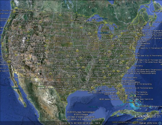
The popular TV show Extreme Makeover: Home Edition recently completed its nine-season run, and user sladys over at Google Earth Hacks has posted a file with the location of virtually every home in the series. It's neat to be able to quickly fly down and view each of these remarkable homes.
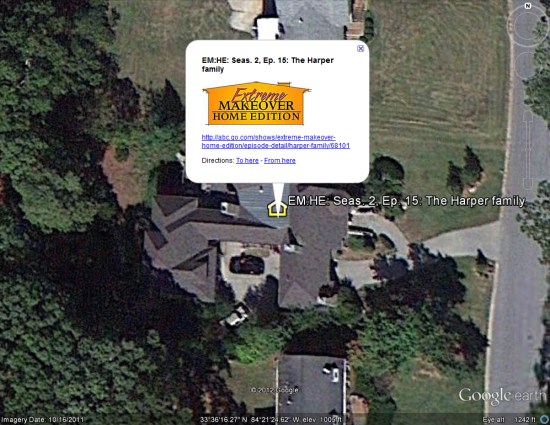 What I found remarkable was the consistent spread of homes across the United States. I don't know if the producers intentionally tried to reach every corner of the country, but that's certainly what happened.
 To see it for yourself, you can download this KML file
 or view the details of it at Google Earth Hacks.
What I found remarkable was the consistent spread of homes across the United States. I don't know if the producers intentionally tried to reach every corner of the country, but that's certainly what happened.
To see it for yourself, you can download this KML file or view the details of it at Google Earth Hacks.
The Ad Exchange developers
The DoubleClick Ad Exchange launched five years ago (logging its first impression in June 2007), and it didn’t take long for the product to open up to developers. In 2008, we launched a real-time bidding (RTB) protocol, enabling sophisticated buyers to analyze and bid for impressions in real time. As the Ad Exchange and RTB grew, so did our pool of developers.
Presently, close to 75 percent of all Ad Exchange spend comes via RTB. Some of our largest buyers are agency trading desks and demand-side platforms that were created around the RTB opportunity. Simply put, Ad Exchange thrives thanks to the work of our developer community.
 Today, we officially welcome Ad Exchange developers to the Google Ads Developer Blog. We’ll be using the blog to update Ad Exchange developers on news, best practices, and beta features. We’ll also highlight upcoming events like webinars, Google+ Hangouts, and on-site Developer Day workshops.
The Ad Exchange team is excited to engage more with our developer community. To subscribe to Ad Exchange news, click on our ad_exchange feed.
Today, we officially welcome Ad Exchange developers to the Google Ads Developer Blog. We’ll be using the blog to update Ad Exchange developers on news, best practices, and beta features. We’ll also highlight upcoming events like webinars, Google+ Hangouts, and on-site Developer Day workshops.
The Ad Exchange team is excited to engage more with our developer community. To subscribe to Ad Exchange news, click on our ad_exchange feed.
Sunday, February 19, 2012
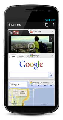
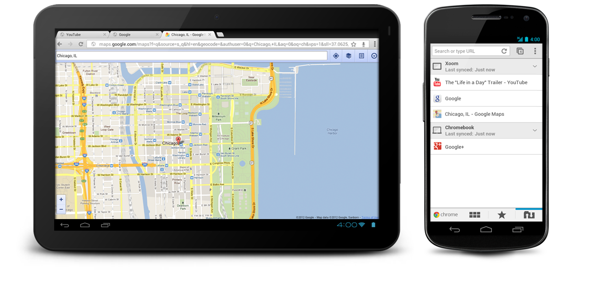
The Chrome for Android
In 2008, we launched Google Chrome to help make the web better. We’re excited that millions of people around the world use Chrome as their primary browser and we want to keep improving that experience. Today, we're introducing Chrome for Android Beta, which brings many of the things you’ve come to love about Chrome to your Android 4.0 Ice Cream Sandwich phone or tablet. Like the desktop version, Chrome for Android Beta is focused on speed and simplicity, but it also features seamless sign-in and sync so you can take your personalized web browsing experience with you wherever you go, across devices.
Speed
With Chrome for Android, you can search, navigate and browse fast—Chrome fast. You can scroll through web pages as quickly as you can flick your finger. When searching, your top search results are loaded in the background as you type so pages appear instantly. And of course, both search and navigation can all be done quickly from the Chrome omnibox.
Simplicity
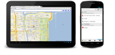
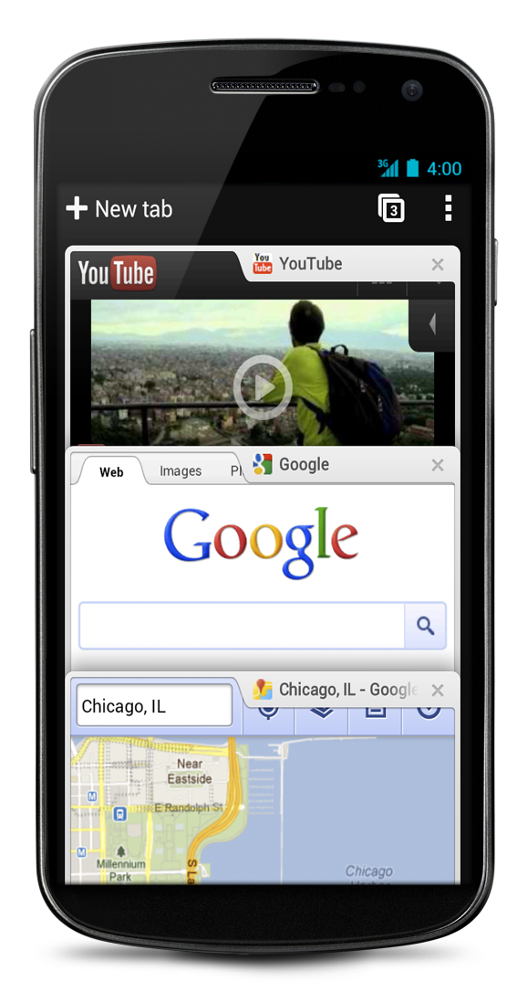
Chrome for Android is designed from the ground up for mobile devices. We reimagined tabs so they fit just as naturally on a small-screen phone as they do on a larger screen tablet. You can flip or swipe between an unlimited number of tabs using intuitive gestures, as if you’re holding a deck of cards in the palm of your hands, each one a new window to the web.
 One of the biggest pains of mobile browsing is selecting the correct link out of several on a small-screen device. Link Preview does away with hunting and pecking for links on a web page by automatically zooming in on links to make selecting the precise one easier.
And as with Chrome on desktop, we built Chrome for Android with privacy in mind from the beginning, including incognito mode for private browsing and fine-grained privacy options (tap menu icon, ‘Settings,’ and then ‘Privacy’).
Sign in
You can now bring your personalized Chrome experience with you to your Android phone or tablet. If you sign in to Chrome on your Android device, you can:
One of the biggest pains of mobile browsing is selecting the correct link out of several on a small-screen device. Link Preview does away with hunting and pecking for links on a web page by automatically zooming in on links to make selecting the precise one easier.
And as with Chrome on desktop, we built Chrome for Android with privacy in mind from the beginning, including incognito mode for private browsing and fine-grained privacy options (tap menu icon, ‘Settings,’ and then ‘Privacy’).
Sign in
You can now bring your personalized Chrome experience with you to your Android phone or tablet. If you sign in to Chrome on your Android device, you can:
 Chrome is now available in Beta from Android Market, in select countries and languages for phones and tablets with Android 4.0, Ice Cream Sandwich. We’re eager to hear your feedback. Finally, we look forward to working closely with the developer community to create a better web on a platform that defines mobile.
 One of the biggest pains of mobile browsing is selecting the correct link out of several on a small-screen device. Link Preview does away with hunting and pecking for links on a web page by automatically zooming in on links to make selecting the precise one easier.
And as with Chrome on desktop, we built Chrome for Android with privacy in mind from the beginning, including incognito mode for private browsing and fine-grained privacy options (tap menu icon, ‘Settings,’ and then ‘Privacy’).
Sign in
You can now bring your personalized Chrome experience with you to your Android phone or tablet. If you sign in to Chrome on your Android device, you can:
One of the biggest pains of mobile browsing is selecting the correct link out of several on a small-screen device. Link Preview does away with hunting and pecking for links on a web page by automatically zooming in on links to make selecting the precise one easier.
And as with Chrome on desktop, we built Chrome for Android with privacy in mind from the beginning, including incognito mode for private browsing and fine-grained privacy options (tap menu icon, ‘Settings,’ and then ‘Privacy’).
Sign in
You can now bring your personalized Chrome experience with you to your Android phone or tablet. If you sign in to Chrome on your Android device, you can:
- View open tabs: Access the tabs you left open on your computer (also signed into Chrome)—picking up exactly where you left off.
- Get smarter suggestions: If you visit a site often on your computer, you'll also get an autocomplete suggestion for it on your mobile device, so you can spend less time typing.
- Sync bookmarks: Conveniently access your favorite sites no matter where you are or which device you’re using.
 Chrome is now available in Beta from Android Market, in select countries and languages for phones and tablets with Android 4.0, Ice Cream Sandwich. We’re eager to hear your feedback. Finally, we look forward to working closely with the developer community to create a better web on a platform that defines mobile.
Saturday, February 18, 2012
The Google Earth seafloor
To celebrate the three year anniversary of the release of the 3D Ocean in Google Earth, they've just released a major update to their bathymetry (underwater terrain) and it looks great!
Similar to their recent update "Pretty Earth" update, this one does quite a lot to help clean up stray artifacts and images visible in the ocean. A great example of that is Guam, seen here alongside the Marianas Trench, the deepest trench in the world:
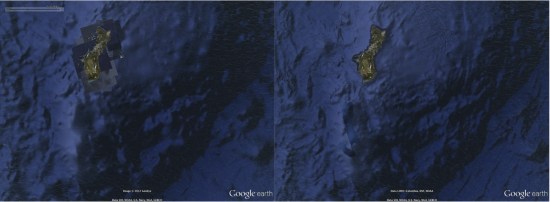 Another noteworthy change is that "Atlantis" is now gone. A few years ago some people thought they had found the lost city of Atlantis, but it turned out to simply be sonar tracks from a ship. While that was a reasonable and accurate explanation, the sonar tracks were still pretty ugly on the surface of the ocean. They're now cleaned up as part of this update and the area looks as clear as it should:
 To see more of what's changed, Google has created this short video to give you a tour:
Combined with the new patchless imagery, the earth is suddenly looking remarkably better all the way around. For more, check out this entry in the Google Lat Long Blog.
To see more of what's changed, Google has created this short video to give you a tour:
Combined with the new patchless imagery, the earth is suddenly looking remarkably better all the way around. For more, check out this entry in the Google Lat Long Blog.
Another noteworthy change is that "Atlantis" is now gone. A few years ago some people thought they had found the lost city of Atlantis, but it turned out to simply be sonar tracks from a ship. While that was a reasonable and accurate explanation, the sonar tracks were still pretty ugly on the surface of the ocean. They're now cleaned up as part of this update and the area looks as clear as it should:
To see more of what's changed, Google has created this short video to give you a tour:
Combined with the new patchless imagery, the earth is suddenly looking remarkably better all the way around. For more, check out this entry in the Google Lat Long Blog.
Subscribe to:
Comments (Atom)