Monday, February 28, 2011

Announcing New Bing Maps & Local Features: Interior Views, Enhanced OpenTable Integration, Real-Time Transit, and Streetside for Mobile

Throughout the last few months, Bing Maps & Local has focused on how our product can help with everyday decisions and deliver innovative experiences to a wide audience. The end result is a more functional, easier-to-use, and differentiated experience. The theme for this release has been around three areas: i) Delivering new types of visual detail, ii) Simplifying local tasks, and iii) Improving maps on mobile. With that in mind, today we’re announcing four new features we’re really excited about:
· Interior Views: Provides users with immersive 360-degree panoramas of local businesses
· OpenTable Integration: Lets users interact with OpenTable directly from restaurant pages
· Real Time Transit on Mobile: Gives users real time info if a bus is on-time or delayed
· Streetside for Mobile: Brings users street-level imagery + some mobile-exclusive enhancements
Interior Views
Have you ever showed up to a restaurant excited to try it for the first time only to be disappointed by its look and feel? Wouldn’t it be great if you could explore the inside of a restaurant just as you can explore the streets with Streetside? Reading reviews of what other people say about a place’s atmosphere is helpful, but you’re the real judge of whether a restaurant’s décor, size, and appearance fit what you’re looking for. And if a picture is worth 1000 words…well, each of our new Interior Views could make a very large book.
· Through a partnership with EveryScape Eats, Bing Local lets you “step inside” and explore full panoramas of restaurants.
· Interior Views are accessed by clicking on the “step inside” panoramic thumbnail on a Bing Local details page.
· Clicking the thumbnail opens the experience (built on Silverlight) and enables you to jump inside the restaurant, move from room-to-room, and explore 360-degree views.
· Current coverage is ~5,000 restaurants (majority Boston metro area) but will be expand continually for breadth and depth in more cities.
A few great examples are: CanlisDavide RistoranteGennaro'sIvy Restaurant

OpenTable Integration
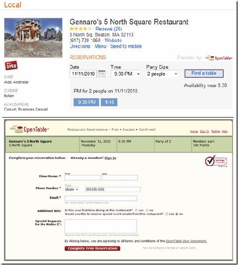
Our new Interior Views help you decide if a restaurant is the right place to go…so it only makes sense to better help you get a reservation. When you go to a local details page for one of the 15,000 restaurants signed up with OpenTable, you can now search for available reservations directly in Bing. Enter in the date, time, and party size and Bing pulls up what’s open. Click on a time you want and you’re brought to the page to finalize your reservation. Simple. To recap:
· Reservations through OpenTable are now available right on the local details pages.
· Every restaurant that is an OpenTable customer will have this functionality.
· Bing Local makes planning a night out easier and faster so you can spend more time on the important things (like what you’re going to eat once you get there!)
Real-Time Transit & Streetside for Mobile
At Bing, we want to help our users answer a lot of questions. Two of these questions are: “When is my bus reallycoming?” and “What’s the place I’m walking to look like?” With Real-Time Transit and Streetside added to Bing Maps on mobile, we can check those two questions off the list.
Real-time Transit for Bing Mobile on the iPhone adds up-to-the-minute data for Seattle, Boston, and San Francisco transit agencies. In one release cycle, Bing added transit routing and is now the first search engine to offer real-time transit information.
Streetside on Bing Mobile gives you the street-level imagery currently available on the desktop but with a few "enhancements.” If you pinch the screen to zoom out, the Streetside imagery will be stitched together so you can flick your finger and easily pan through streets. Also, the names of local businesses in the current street-level view appear under their respective buildings so you can learn more about what you’re seeing.
Below is a video to see Real-time Transit in action, but to learn more about the entire Bing Mobile release and see all the features and screenshots, head to the Bing Mobile Post.

Apple представя iPad 2 на 2 март?

На 2 март Apple ще представи iPad 2 на специално събитие за медиите, съобщава авторитетният блог All Things D. Събитието ще се проведе в Yerba Buena Center в Сан Франциско – предпочитано от компанията място за представяне на нови продукти.

Предстоящият таблет на Apple е една от горещите теми в технологичните медии в последните седмици. Много източници твърдят, че iPad 2 ще бъде по-тънък и по-лек от настоящия, доставките на който започнаха миналия април.

Очаква се iPad 2 да бъде с двуядрен процесор, по-добър екран, повече RAM, повече дисково пространство и две камери – предна и задна. Също ще поддържа GSM и CDMA мрежи.

За разлика от настоящия iPad, новия ще срещне усилена конкуренция както в потребителския, така и в бизнес сегмента.

Доставките на Xoom на Motorola – един от таблетите, базирани на Android 3.0, ще започнат тази седмица от Verizon Wireless.

Galaxy Tab 10.1 на Samsung бе представен тази седмица на Mobile World Congress в Барселона – той също е с Android 3.0 и доставките му ще започнат през юни.

Research in Motion (RIM) планира в края на годината да пусне версии на таблета й PlayBook за LTE (Long-Term Evolution) и 3G HSPA+ високоскоростни мрежи от последно поколение за пренос на данни. WiMax и Wi-Fi версии на PlayBook ще бъдат налични в магазините от следващия месец.

През лятото ще започнат доставките на Hewlett-Packard WebOS.

Street View for Ireland & Brazil Launched


Google today added Street View imagery to the Republic of Ireland, Brazil and a tiny bit of Antartica. The coverage in Ireland seems to be pretty comprehensive. In Brazil the imagery seems to be concentrated in Rio de Janerio, Sao Paulo and Belo Horizonte.
Here are some of the sights you can view in the new imagery:

Carnival, Sao Paulo

The GPO, Dublin

Christchurch Cathedral, Dublin

St Finbarre’s Cathedral, Cork

Kylemore Abbey

Museu de Arte Contemporânea de Niterói

São Paulo Cathedral

Antarctic

Penguins!
These websites have collections of interesting sights found on Street View. You can bet that they will all be busy adding Irish and Brazilian finds to their collections today:
One Developer has also been very quick to produce three websites dedicated to collecting interesting Street Views from Brazil:
http://www.sampaview.com (São Paulo)
http://www.riostreetview.com (Rio de Janeiro)
http://www.bhnomapa.com Belo Horizonte

Google Map Maker and UNITAR Collaboration Shines at Shanghai World Expo | Mapsys.info

Google Map Maker and UNITAR Collaboration Shines at Shanghai World Expo | Mapsys.info


This past weekend at the 2010 World Expo, UN Institute for Training and Research (UNITAR) and Googlegave a joint presentation and informational session about their recent work together in global humanitarianmapping.

Illustrating his remarks with information about the Pakistan 2010 flood relief efforts, UNITAR Geospatial Analyst Josh Lyons explained how Google Map Maker helps his organization quickly and accurately produce geospatial products and emergency response maps. By leveraging the high quality, up-to-date information provided by users in Google Map Maker, UNITAR is able to produce and distribute helpful composite map products using tools such as UNITAR’S Operational Satellite Applications Programme (UNOSAT). These products played a key role in facilitating modern humanitarian relief for the recent disaster in Pakistan.

UNITAR/UNOSAT map for Pakistan flood analysis, with transport data from Google Map Maker

Dr. Carlos Lopes, United Nations Assistant Secretary-General and Executive Director of UNITAR, expressed his excitement both to work with Google and that UNITAR/UNOSAT resources that had previously been spent on mapping data collection could now be invested directly into analysis. He remarked that users and beneficiaries aided by this collaborative effort include operational UN agencies, international NGOs and national entities from government and civil societies, and of course, the people directly affected by disasters and other crises.

We hope that the interest and increased awareness that the Shanghai World Expo event generated about Google Map Maker helps to build an even stronger user community. It’s the online mapping contributions of volunteers across the globe that enable Map Maker to be a valuable tool for humanitarian activities like this as well as a source of quality maps in the developing world. Let’s continue mapping the world together!

Sunday, February 27, 2011

Five Great Styled Maps Examples

Last May at Google I/O, we introduced Styled Maps which offers control over map features and color schemes. Stylishly ending the “one-size-fits-all” approach to base maps.

This new cartographic concept was met with a lot of excitement for where developers would take it and since launch we’ve seen some very innovative work. Listed below are five great examples of Styled Maps.

London at Night


Mapnificent’s “London at Night” dynamically displays bus travel time. The base map is styled to create a nighttime feel and to emphasize major roads. Additionally, the darker base layer creates a better contrast for the isochrone visualization.

Athens Taxi Cost Calculator


This taxi calculator differentiates itself (and adds some Greek flare) by turning the base map black and the roads blue. Queried taxi routes are displayed in a highly contrasted red.

Google 2010 Election Ratings Map


Josh Livni and the Elections Team here at Google did a great job styling this election rating map. Features that are less relevant to the overlaid data (such as roads, landscape features, and bodies of water) have been lightened and no longer visually compete for attention. Whereas state and city labels, which are of high relevance, remain easy to read. The mash-up is powered by Fusion Tables, which integrates easily into Google Maps API v3.

Ubilabs’ Tour de France live tracker


In order to focus attention on the Tour de France route, Ubilabs grayed out the entire base map. With the rest of the map a much less interesting black and white, a red curving line emerges as the dramatic centerpiece of this mash-up.

Aquila Shoes Store Locator


Australian retailer Aquila Shoes used Styled Maps to match their branding and website color schemes.

Honorable Mention
Maps Without Maps


Maps without Maps challenges us to rethink how we interact with maps. Using Styled Maps to show only labels, finding a location on the map suddenly feels like a foreign task. It’s a wonderful thought-provoking experience.

Update 10/7/10:

Team Coco Blimp Tracker


On Wednesday, October 6, 2010, Conan O'Brien launched a giant orange blimp to publicize his new show on TBS. As Conan joyrides across the US east coast, fans all over the world can track the blimp in real time using Google Maps. Styled Maps was used to turn the roads orange: a nod to the blimp and Conan's famous hair.

5 Great Ad Commercial Campaigns + Maps

The Google Maps API has always been a great way to visualize data, but recently more and more advertising agencies are realizing the potential that the Maps API has for creative and engaging product campaigns.

Whether it’s automobiles, zombie trains, a blockbuster action movie, a board game, or even a bathroom cleaning product, there’s a map application for that product and it is changing the face of interactive advertising.


Domestos Flush Tracker


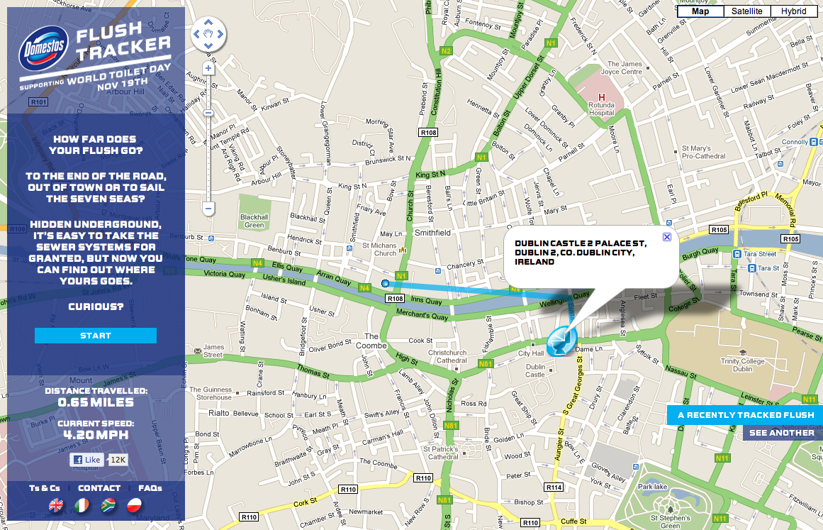
Domestos is a brand of bleach sold in the UK, South Africa, and Poland. As an advertising campaign for this bathroom product, Domestos created a “Flush Tracker” that lets you track where your flush goes after it leaves your house and enters the local sewer system. The animated line on the map simulates the speed at which refuse moves the through sewer system.


A-Team - Drive the A-Team Van


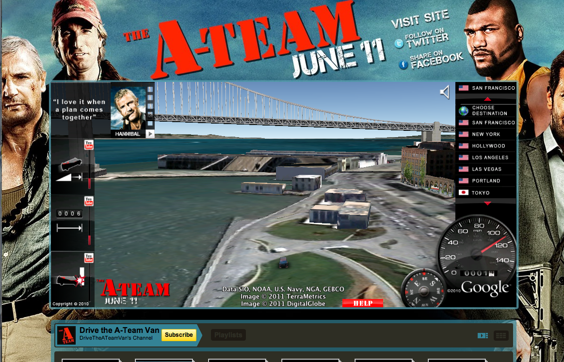
Nothing is more iconic of the A-Team than Mr. T’s van. Using the Earth API, users can drive Mr. T’s van through 3D models of 15 international cities. This implementation was seamlessly embedded into a YouTube landing page for the movie, where users can watch special movie clips that are unlocked by completing certain driving stunts.


Virgin Trains - Don’t Go Zombie...


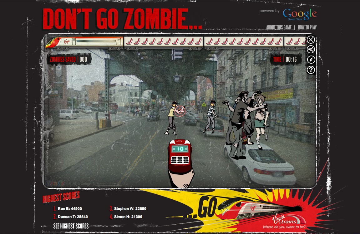
From Virgin Trains, “The streets have been taken over by frustrated car-driving zombies who need to be saved. They have to get to the comfort of a Virgin Train and only you can help them with your special ticket machine. Follow the Map to get to your destination, saving zombies on the way.”


Alfa Romeo - Virtual Ownership


Using the Street View API, users can plug in their address and virtually place an Alfa Romeo Giulietta in their driveway. The size, color, and positioning of the vehicle can also be manipulated, creating the perfect postcard to share on Facebook, Twitter, or email to a friend.

Monopoly City Streets


Although no longer live, this highly addictive, global Google Maps version of Monopoly will always be remembered as a great advertising campaign. Users could buy any street in the world and build hotels, houses, stadiums, castles and skyscrapers (to name a few). Fortunately, this truly unique idea was well documented and you can view demos of the game on YouTube: http://goo.gl/p0aEh and http://goo.gl/uXx4k

Saturday, February 26, 2011

Geography as art

While maps are often considered guides to get from here to there, on the Google Maps and Earth team, we’re constantly thinking of innovative ways to express geographic information. From helping you see the world from a street-level perspective with Street View, to enabling you to dive into the Ocean layer in Google Earth, new geographic visualizations are top of mind for the team. With that mapping mindset, Group Product Manager Lior Ron was struck by the abstract landscape paintings he saw at the Sausalito art festival.
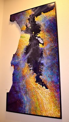
Ben Joyce’s painting of San Francisco caught his attention: “The color scheme, brush strokes, and the open frame prompted my imagination freely to think about San Francisco and what I love about this city. What a wonderful way of visualizing spaces!”
San Francisco at Night by Ben Joyce
Ben describes his work as Abstract Topophilia: “The affective bond between people and place. The Love of Place,” and explains how cities like San Francisco inspire his artwork: “There is great beauty and intrigue in the layout of a city - from your everyday drive to work, to the historical creation of the streets, to your personal relationship with the town."
When Lior shared Ben’s work with some teammates, we too were fascinated by the bold color schemes and dramatic visualizations of geographic information, and were thrilled to learn that Ben has consulted Google Earth to create his city artwork. To share these creative visualizations with the team, we invited Ben to show some of his artwork in our team building, with depictions of cities ranging from Florence to Moscow.
Moscow by Ben Joyce
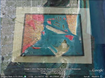
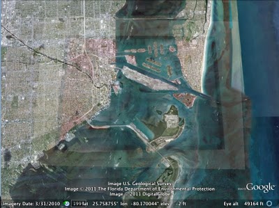
When we first hung up the paintings, we omitted location descriptions and opened a contest for the team: who could identify all of the paintings first? Google Earth Community Program Manager Robin Ziegler identified all of the locations about 30 hours after we started the challenge, and even plotted all of the paintings in Google Earth. Here you can see how Robin aligned Ben’s painting of Miami with the corresponding imagery in Google Earth.


Ben’s artwork will stay in our team’s building for the next three months, and will continue to remind us of the creative potential of geographic information.
Posted by Emily Henderson, Administrative Assistant, Google Maps & Earth

How often does Google update the imagery in Google Earth? | Mapsys.info

How often does Google update the imagery in Google Earth? | Mapsys.info

Viewing the Big Picture with Google Maps | Mapsys.info

Viewing the Big Picture with Google Maps | Mapsys.info

The Big Picture Small World is a mashup of Boston.com’s The Big Picture and Google Maps. The map uses the Yahoo! Query Language to grab the RSS feed of Boston.com’s Big Picture series and to map the pictures on Google Maps.

The locations of the pictures are determined by the image captions and not by any geographical metadata in theimages. This is pretty accurate in most cases but does lead to some of the images being mapped in the wrong location.

Brazilian Street View Collections | Mapsys.info

Brazilian Street View Collections | Mapsys.info

Community Action on Google Maps | Mapsys.info

Community Action on Google Maps | Mapsys.info

Creek Speak is an oral history project that uses Google Maps to present the stories of people and places near Newtown Creek, New York. The map is part of the Creek Speak Project which has been designed to inspire community action by identifying shared health and environmental concerns and demonstrating the possibilities for positive change.

Stone Owl retracted from Bohemian Grove Aerial Maps | Mapsys.info

Stone Owl retracted from Bohemian Grove Aerial Maps | Mapsys.info

Brazilian Street View Collections | Mapsys.info

Brazilian Street View Collections | Mapsys.info

Community Action on Google Maps | Mapsys.info

Community Action on Google Maps | Mapsys.info

Final Android 3.0 Platform and Updated SDK Tools


We are pleased to announce that the full SDK for Android 3.0 is now available to developers. The APIs are final, and you can now develop apps targeting this new platform and publish them to Android Market. The new API level is 11.

For an overview of the new user and developer features, see the Android 3.0 Platform Highlights.

Together with the new platform, we are releasing updates to our SDK Tools (r10) and ADT Plugin for Eclipse (10.0.0). Key features include:
  • UI Builder improvements in the ADT Plugin:
    • New Palette with categories and rendering previews. (details)
    • More accurate rendering of layouts to more faithfully reflect how the layout will look on devices, including rendering status and title bars to more accurately reflect screen space actually available to applications.
    • Selection-sensitive action bars to manipulate View properties.
    • Zoom improvements (fit to view, persistent scale, keyboard access) (details).
    • Improved support for layouts, as well as layouts with gesture overlays.
  • Traceview integration for easier profiling from ADT. (details)
  • Tools for using the Renderscript graphics engine: the SDK tools now compiles .rs files into Java Programming Language files and native bytecode.
To get started developing or testing applications on Android 3.0, visit the Android Developers site for information about the Android 3.0 platform, the SDK Tools, and the ADT Plugin.

The Data Viz Challenge: can you make tax data exciting?

This time of year, everyone in the United States is starting to fill out—with varying levels of enthusiasm—our federal income tax forms. Yet, after we write our checks to the IRS, most of us don’t really know exactly where our money is going.

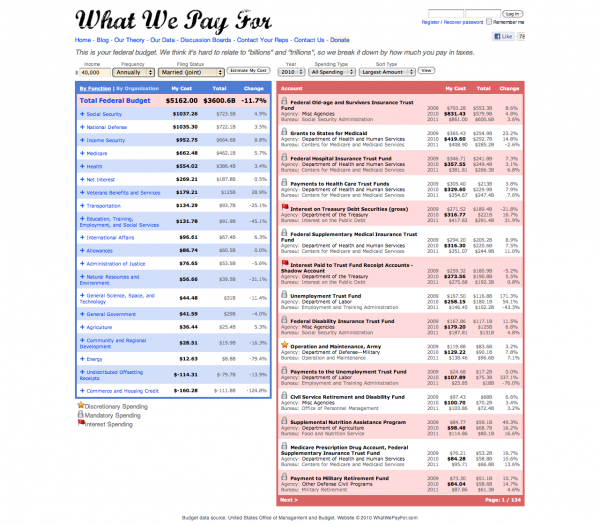
Fortunately, there’s a new online tool to help us find out. Last year, Andrew Johnson and Louis Garcia, two developers from Minneapolis, Minn., created a website called whatwepayfor.com that uses public data to estimate how our tax money is spent. You enter your income and filing status on the site, and it creates a formatted table of numbers showing your contributions to the federal budget—down to the penny:


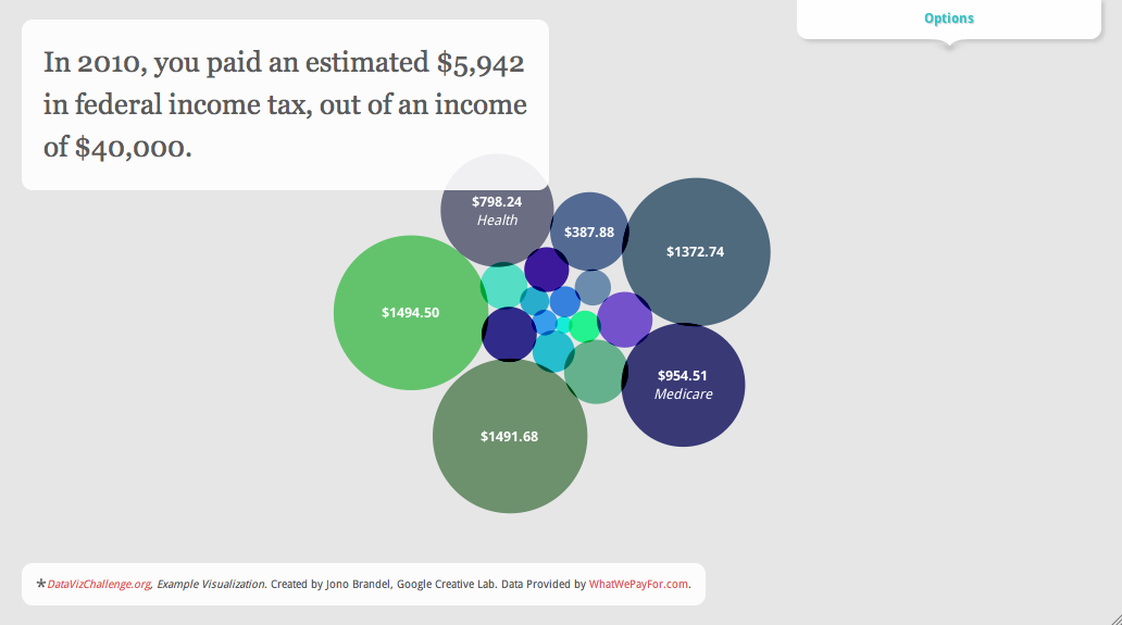
We’re impressed by what the website uncovers. In 2010, for example, a married couple making $40,000 a year contributed approximately $14.07 to space operations, $6.83 to aviation security and $0.91 to the Peace Corps…and those are just a few of the hundreds of expenditures revealed on the site. As we spent time exploring all of these details, it got us thinking: how we could make the information even more accessible? So we created a simple interactive data visualization:


Click the image above to try the interactive version—it lets you drag the bubbles around, change the income level and so on. You can now look at the data in a new way, and it’s a little more fun to explore. Of course, there are lots of ways to visualize the data, and we’re very sure there are many talented designers and developers around the country who can do it even better than we have.

To make that happen, we’ve teamed up with Eyebeam, a not-for-profit art and technology center, to host what we’re calling the Data Viz Challenge. Andrew and Louis have built an API to let anyone access the data, so now you can choose how to display it. Could you create a better animated chart? Something in 3D? An interactive website? A physical display somewhere in the real world? We want you to show everyone how data visualization can be a powerful tool for turning information into understanding.

You can enter the challenge at datavizchallenge.org, where you’ll also find more information about challenge and the data. The challenge starts today and ends March 27, 2011, and is open to the U.S. only. The top visualization, as chosen by a jury, will receive a $5,000 award and a shout-out on the site and this blog. We’ll announce the shortlist on the week of April 11, and the winners on April 18, a.k.a. Tax Day.

If you’re a data viz enthusiast, we hope you’ll take a look at the data and build your own creative visualization. But even if you’re not, hopefully the results will help you appreciate what data visualization can do, and its usefulness in turning raw information—like federal income tax numbers—into something you can explore and understand.

Следенето във Facebook стана по-лесно с Breakup Notifier

На вниманието на всички, които са проверявали семейното положение и стената на някой приятел във Facebook, към когото все още таят чувства, или пък на новите си избраници: това дебнене става по-лесно благодарение на Breakup Notifier! Това ново приложение, което известява по и-мейл, когато съответната цел смени семейното си положение, даващо възможност да се втурнете в авантюра, докато Вашият избраник е все още уязвим.


По-интересното в случая обаче, е как е хрумнала идеята за това приложение. Дан Льовенхерц, създателя на приложението, си седял един ден, опитвайки се да намери приятел на сестрата на своята годеница. Но когато погледнал профила му във Facebook, открил, че въпросният господин е във връзка. Както някой би направил в подобно затруднение, Дан прекарал 4 часа в програмиране, създавайки услуга, която Ви уведомява всеки път, когато човекът, към когото имате интерес, смени своето семейно положение.


Приложението работи по следния начин - на всеки 10 минути изпраща ping до Facebook, за да провери съответния семеен статус. Това е наистина полезно, когато нямате достъп до избрания/избраната, също така е и дискретно, така че докато не споделите пред някого, че използвате Breakup Notifier, няма да има по-информиран от Вас.

Всичко, което трябва да направите е да се логнете в Breakup Notifier , използвайки Вашия Facebook акаунт, да изберете приятелите, които да следите и дебненето започва. Бързо и лесно.

Льовенхерц е също собственик на сайтовете areweenemiesyet.com , които пък уведомяват всеки път, щом някой Ви премахне от списъка си с приятели. Има информация, че Дан възнамерява да сложи символична цена от 99 цента за първите потребители, а след време цената да скочи до $4,99. Така че, като че ли сега е времето да се регистрирате, докато все още е безплатно.

Got ideas? We're listening.

In the past several months we’ve added several new features to Google Custom Search – and we have you to thank! More than a year ago, we told you about a new Google Custom Search Product Ideas page, and since then you’ve voted thousands of times on all sorts of great ideas for improving the product. That doesn't even include the stellar suggestions we get on a regular basis in the help forum. In fact, query autocompletion was a help forum suggestion from swoodby that’s now available with just a few clicks in the Control Panel. We’re thrilled that we have this productive feedback loop with you, and want to report back on some of the product iterations we made during the past year.

Wireless data consumption has more than doubled every year, so we’re happy to have added mobile search features to the product. As requested on the Product Ideas page, users can now search on your website using their mobile devices. The default homepage for your custom search engine is now optimized for your on-the-go users. We will continue to optimize Custom Search to meet the needs of a growing mobile user base.

In response to your requests for metadata capabilities, we launched a set of features to support structured custom search. You now have the ability to filter by attributes such as author, define attribute ranges such as dates, and sort by specific attribute values such as ratings. We plan to make these metadata features even easier to use through the Custom Search Element, which generates code that you can copy and paste to easily add Custom Search to any website.

You’ve also made it clear from your feedback that you love customizing your search engine and adding your own flair. So, over time we’ve made it possible for you to tweak the layout of your results, customize your synonyms, control autocompletions, and apply custom styles to your search engine. Now it’s even possible to select a theme for your ads.

What’s the moral of the story here? Your mic is on and we’re listening. Keep the feedback coming in the help forum (the Product Ideas page is closed for now) and we’ll continue working to make Custom Search better. After all, it’s really your product.

76 процента от лондончани против покритие за телефоните си в метрото

Извадка от 1094 лондончани показва, че само 24% искат покритие на своите клетъчни телефони и в Лондонското метро. Останалите 76% са против, сочи проучването, направено от GoodMobilePhones.co.uk.

Това проучване бе провокирано от потвърждението на китайската компания за мрежови технологии Huawei, че ще наддава в борбата за снабдяването на метрото с мобилно покритие навреме за Олимпийските игри през 2012-та.


От хората, обявили се против построяването на мрежата от Huawei, 31% се обосновават, че се страхуват от потенциални крадци и разбойници, докато 16% вярват, че използването на техните телефони в подземната мрежа ще доведе до покачване на месечните им сметки.

Въпреки това обаче, 24% от анкетираните посочват идеята за подземно използване на телефоните си като добра, обосновавайки се, че мобилният достъп ще направи по-лесен достъпа до спешни услуги в съответните ситуации.

Основателят на GoodMobilePhones.co.uk Марк Оуен каза: "Новините за подземна мобилна мрежа със сигурност предизвикват вълнение у хората, но съм изненадан колко много от лондончани са против нея. Очевидно има рискове с повишаването на покритието в метрото, но това са неща, които могат да бъдат преодолени. Съществуването на подземна мобилна мрежа е следващата логична стъпка, вървейки по стъпките на Париж и Хонг Конг, които нямат никакви съществени проблеми" - завърши той.

GetListed Portland

Today, I am presenting at the sixth GetListed.org Local University in Portland, Or. If you are coming PLEASE take a moment to introduce yourself as I would love to meet you.

For those of you that attended the presentation these links will provide background information and details for a pathway to dig deeper into the world of managing your listing on Google Maps. For those of you that are not in attendance, the links provide a good overview of critical base line ideas and tactics that every local campaign should embrace.
Google Maps – Its not your mother’s yellow pages.

Slide 2 - January 2011 Search Engine Market Share
Slide 12/13 - The Importance of Page One Visibility
Slides 16/17 - How the Google Cluster Works
Slide 21- Choosing the Right Category – A Tool
Slide 21 - Writing a Great Business Description
Slide 21 - Google Places Policies: Quality guidelines
Slide 22 - Creating a GeoSitemap – A tool
Slide 28/29 Local Search Ranking Factors – the many variables
Slide 28/29 A brief list of 10 Ranking Factors – somewhat old but still valid and a quick read
Slide 28/29 Thinking about your Business Name in the Internet Era
Slide 30 - Custom Maps – A Goldmine
Slide 30 - User Generated Content – Geo Tagged Photos
Slide 30 - How To Gather Reviews
Slide 30- Where to Gather Reviews
Slide 31- The Importance of Citations
Slide 31 - 20 Citation Sources in the US
Slide 36- A Listing management tool

Related posts:
  1. GetListed Local U, Cleveland
  2. GetListed Local University – Twin Cities
  3. GetListed Birmingham

След няколко седмици Adobe ще пусне Flash за Android OS 3.0

т Adobe Systems заявиха, че през слядващите няколко седмици ще публикуват версия на своя Flash Player с поддръжка на новата операционна система Android Honeycomb 3.0, предназначена за работа на интернет таблети. Според представители на компанията, Honeycomb е първата версия на Android, специално разработена за устройства с по-голям екран от дисплея на смартфон, което обаче поставя към Flash повишени изисквания.

Мат Розен, представител на Adobe, казва, че по оценки на фирмата, през тази година на световния пазар ще се появят около 50 различни модели таблети с поддръжка на Flash, като първият от тях ще бъде Motorola Xoom на цена около 800 долара. В блога на компанията се отбелязва, че до края на тази година Flash ще работи на 132 милиона устройства, които поддържат тази среда.

Преди няколко дни Adobe показа нова версия на Flash за смартфони с поддръжка на технологията Stage Video, създадена с цел намаляване на натоварването върху процесора и икономия на ток от батерията на мобилните устройства. Том Нгуен, мениджър по продуктовата серия Flash, твърди, че Stage Video използва всички възможности за хардуерно ускорение на целия видеопоток.

"Stage Video означава, че Flash Player може да възпроизвежда видео с най-добро добро качество и по-ниска консумация на системни ресурси, което позволява на потребителите да се възползват по-пълно от него и устройството. В памките на нашия вътрешен тест беше констатирано, че натоварването на системите в някои случаи намалява до 34 пъти" - казва Нгуен.

Според него, съвременните компютри, работещи под операционните системи Windows или Mac и имащи инсталиран Flash Player 10.2, HD-видео с резолюция 1080р се възпроизвежда с 15% натоварване на процесора. Ще припомним, че по-рано много разработчици на мобилни платформи, включително Apple, критикуваха Adobe за прекалено активното използване на системни ресурси и високото натоварване на процесора при показване на Flash видео.

Нгуен добави още, че Video Stage може да обработва се справи не само видео, но и различните други компоненти, като например текст, изскачащи елементи, както и елементи за управление на възпроизвежданото видео. Преди поддръжката на всички тях съществуваше само в случаите, когато видеото беше кодирано във формат H.264, а сега системата работи във всички формати.

Motorola Atrix вече може да се купи от AT&T, Amazon и Walmart

Първият Android телефон на Motorola - Atrix, вече може да се купи от AT&T, както и от търговци като Amazon, Walmart и Radioshack.

Цената на телефона е $199,99 ако се закупи от AT&T, но условието е подписване на двугодишен договор. Нещата при Amazon и Radioshack седят малко по-различно - цената там е $149,99, а в Walmart цената от $129,99 е промоционална, но е достъпна само ако активирате своя акаунт преди четвъртък.

Смартфонът Atrix е един от най-мощните на пазара, работещи с операционна система Android 2.2 - той има двуядрен 1GHz процесор Nvidia Tegra, 1GB RAM памет и 960x540 qHD екран. Освен това той е и много гъвкав откъм възможности, защото притежава опцията да се свързва с лаптоп или други мултимедийни устройства, което наистина значително увеличава функционалността му.


Така излизането на телефона на пазара изпревари първоначалната официално обявена дата 1-ви март.

Create Your Own Google Map | Mapsys.info

Create Your Own Google Map | Mapsys.info

Community Action on Google Maps | Mapsys.info

Community Action on Google Maps | Mapsys.info

Brazilian Street View Collections | Mapsys.info

Brazilian Street View Collections | Mapsys.info

Поредната антитръстова жалба срещу Google

Европейската комисия започна поредното разследване срещу IT магнатите от Google. От ЕС ще трябва да преценят дали компанията е в нарушение с антитръстовите закони и дали поведението й ограничава свободната и лоялна конкуренция.

Жалбата до Европейската комисия е подадена от 1plusV. Това е френска компания, специализираща в областта на търсачките. Според нея и според написаното в оплакването Google постоянно извършва действия, които възпрепятстват по-малките си конкуренти да генерират приходи, тъй като интернет групата злоупотребява с доминиращата си позиция на пазара на търсене.

Всъщност 1plusV е собственик на френската търсачка eJustice.fr. Тя се явява една от подалите жалба срещу Google през ноември миналата година. С още две по-малки и тепърва разрастващи се компании 1plusV обвиняват интернет гигантите в това, че дискриминира в резултатите си при търсене сайтовете на фирми, предлагащи конкурентни на нейните услуги.

Новата антритръстова жалба, подадена до Европейската комисия, посочва и нови нарушения на Google. Те продължават да са си от същото естество – злоупотреба с господстващо положение и поведение, създаващо условия за нелоялна конкуренция. В оплакването се подчертава няколкократно, че Google са изтрили от резултатите си eJustice.fr и 1plusV. Отговорът на IT магнатите съдържаше обяснение, че показването на техните резултати в търсачката се базира на рангова система – тези резултати зависели от значимостта на дадена страница и на нейната популярност сред онлайн аудиторията.

От Google се и оправдаха, че не веднъж са отправяли предложения към стотица сайтове за подпомагането им, за да станат по-известни за потребителите. Интернет гигантите добавиха и, че са наясно с европейските закони срещу нелоялна конкуренция и злоупотребата с господстващо положение. Нещо повече – Google твърдят, че ЕК е наясно с техния бизнес модел – но това не означава, че компанията не би изразила готовност да промени някои от стратегиите си, за да задоволи и законотворците, и потребителите си.

Немско приложение за iPhone показва локации, достъпни за хора в инвалидни колички

Раул Краутхаузен, който е в инвалидна количка от дете, споделя негативно мнение за услугите, които Германия предлага за хората с физически увреждания. Според него услуги, като специалните таксита и доставките на хранителни продукти, нерядко са покровителствени и го изолират още повече.

За това той поема нещата в свои ръце, като създава wheelmap.org – приложение за iPhone и уеб сайт на английски и немски, които позволяват на потребителите да споделят класации и съвети относно достъпността на магазини, барове и други места.

„Искам да бъда подвижен и да не завися от това, кога дадена транспортна фирма ще има време да ме вземе”, споделя Раул. Оказва се, че не само той се чувства по този начин. Сайтът получава 300 нови потребителски рейтинги дневно и към този момент дава информация за около 30 000 локации. Около 80% от коментираните места са в Германия, но базата данни бавно се разраства и към градове като Лондон и Ню Йорк.

„Целта на Wheelmap.org е да помага на хората с физически увреждания да научават за места, които са достъпни за тях”, допълва още създателят на сайта.

Според Краутхаузен успехът на Wheelmap се дължи на достъпността му чрез iPhone апликация, както и на т.нар. „Wiki принцип” – идеята, че всеки може да допринесе за развитието на сайта. Потребителите могат да класират локации без да се регистрират, но трябва да го направят, ако искат да добавят специални коментари.

Resources for the latest Christchurch earthquake

It was just last September that we were discussing the earthquake that struck Christchurch, New Zealand, and now they've been hit by another powerful quake.

As you might expect, and as reported by Google Maps Mania, there are already a variety of resources available to assist those in the area.

The easiest is the Google Person Finder for Christchurch, to help track down anyone that has been affected by the earthquake. You can use the site if you're looking for someone, or if you know the condition of someone that others may be looking for. As of now, the site already has nearly 5000 records.

Along those lines, I'm very happy to report that Frank is doing well. Him and Karen were in Christchurch when the quake struck, and while they saw a lot of damage around them, they are unharmed. You can read about it on the Tahina Expedition blog, which includes some photos he has just taken in Christchurch.

cathedral.jpg

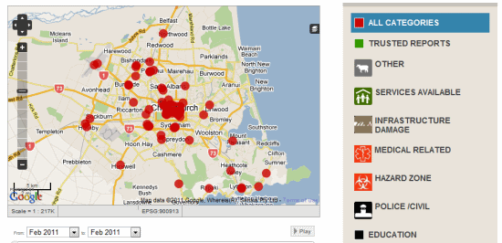
Another great resource for the quake is this very useful Ushahidi-powered site, which provides information about hospitals, road conditions, hazard zones and other related information. It's an excellent resource to have available if you're on the ground in the area.

ushahidi.png

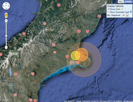
Finally, I encourage you to check out the Christchurch Quake Map, which shows all of the quakes and aftershocks in the area for the past year (nearly 5,000 of them). You can filter the map to show only the 55 quakes that have struck in the past 24 hours.

quake-map.png

If you're aware of any other great resources, please leave a comment and we'll update this post as needed.

Share This: