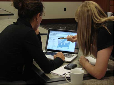
 Google Earth Outreach team member Tanya Birch works with a participant on Fusion Tables.
We kicked off the week with a 3-day workshop co-hosted with our partner Tides Canada. With their help, we were able to gather developers, communications and technology professionals from over 50 organizations to be trained on Google Earth, Google Maps and Google Fusion Tables. We met folks from a diverse set of organizations, such as Ecotrust Canada, Social Alterations, Living Oceans Society, and Inuit Tapiriit Kanatami.
These groups came into the workshop with varying levels of familiarity with Google’s geo tools. While some participants leveraged the time to master the basics, others focused on advanced coding using the Maps APIs. Non-profits developed and worked on their project ideas with Earth Outreach staff on hand for guidance and technical help. Our team was amazed by some of the projects that came out of these sessions, including a Google Fusion Table map of Inuit communities and a Google Earth tour of the path of a migrating whooping crane.
Our activities in Vancouver culminated in an event on Wednesday for the wider Vancouver non-profit community. We were honored to have David Suzuki, an influential Canadian scientist, author, broadcaster and co-founder of the David Suzuki Foundation, on hand to share his thoughts on how philanthropy, public engagement and technology can advance the reach, scope and impact of Canadian civil society. Our team’s founder, Rebecca Moore, also took the stage to demonstrate how the rich variety of environmental and social issues in Canada can benefit from geographic visualizations as powerful tools for environmental advocacy and social justice. Afterwards, our team got to interact with the community face-to-face at demo stations featuring Google Earth, Google Maps, Google Fusion Tables, Open Data Kit as well as already developed Canadian mapping projects.
Google Earth Outreach team member Tanya Birch works with a participant on Fusion Tables.
We kicked off the week with a 3-day workshop co-hosted with our partner Tides Canada. With their help, we were able to gather developers, communications and technology professionals from over 50 organizations to be trained on Google Earth, Google Maps and Google Fusion Tables. We met folks from a diverse set of organizations, such as Ecotrust Canada, Social Alterations, Living Oceans Society, and Inuit Tapiriit Kanatami.
These groups came into the workshop with varying levels of familiarity with Google’s geo tools. While some participants leveraged the time to master the basics, others focused on advanced coding using the Maps APIs. Non-profits developed and worked on their project ideas with Earth Outreach staff on hand for guidance and technical help. Our team was amazed by some of the projects that came out of these sessions, including a Google Fusion Table map of Inuit communities and a Google Earth tour of the path of a migrating whooping crane.
Our activities in Vancouver culminated in an event on Wednesday for the wider Vancouver non-profit community. We were honored to have David Suzuki, an influential Canadian scientist, author, broadcaster and co-founder of the David Suzuki Foundation, on hand to share his thoughts on how philanthropy, public engagement and technology can advance the reach, scope and impact of Canadian civil society. Our team’s founder, Rebecca Moore, also took the stage to demonstrate how the rich variety of environmental and social issues in Canada can benefit from geographic visualizations as powerful tools for environmental advocacy and social justice. Afterwards, our team got to interact with the community face-to-face at demo stations featuring Google Earth, Google Maps, Google Fusion Tables, Open Data Kit as well as already developed Canadian mapping projects.
Wednesday, October 12, 2011
Outreach and Canadian mapping tools
Last week Google Earth Outreach launched our program in Canada, offering support to non-profits and aboriginal communities that wish to leverage Google’s mapping tools to improve understanding of critical issues facing Canada today. Our team spent the week in Vancouver inspiring and empowering these groups to spread their message through geographic visualizations.
 Google Earth Outreach team member Tanya Birch works with a participant on Fusion Tables.
We kicked off the week with a 3-day workshop co-hosted with our partner Tides Canada. With their help, we were able to gather developers, communications and technology professionals from over 50 organizations to be trained on Google Earth, Google Maps and Google Fusion Tables. We met folks from a diverse set of organizations, such as Ecotrust Canada, Social Alterations, Living Oceans Society, and Inuit Tapiriit Kanatami.
These groups came into the workshop with varying levels of familiarity with Google’s geo tools. While some participants leveraged the time to master the basics, others focused on advanced coding using the Maps APIs. Non-profits developed and worked on their project ideas with Earth Outreach staff on hand for guidance and technical help. Our team was amazed by some of the projects that came out of these sessions, including a Google Fusion Table map of Inuit communities and a Google Earth tour of the path of a migrating whooping crane.
Our activities in Vancouver culminated in an event on Wednesday for the wider Vancouver non-profit community. We were honored to have David Suzuki, an influential Canadian scientist, author, broadcaster and co-founder of the David Suzuki Foundation, on hand to share his thoughts on how philanthropy, public engagement and technology can advance the reach, scope and impact of Canadian civil society. Our team’s founder, Rebecca Moore, also took the stage to demonstrate how the rich variety of environmental and social issues in Canada can benefit from geographic visualizations as powerful tools for environmental advocacy and social justice. Afterwards, our team got to interact with the community face-to-face at demo stations featuring Google Earth, Google Maps, Google Fusion Tables, Open Data Kit as well as already developed Canadian mapping projects.
Google Earth Outreach team member Tanya Birch works with a participant on Fusion Tables.
We kicked off the week with a 3-day workshop co-hosted with our partner Tides Canada. With their help, we were able to gather developers, communications and technology professionals from over 50 organizations to be trained on Google Earth, Google Maps and Google Fusion Tables. We met folks from a diverse set of organizations, such as Ecotrust Canada, Social Alterations, Living Oceans Society, and Inuit Tapiriit Kanatami.
These groups came into the workshop with varying levels of familiarity with Google’s geo tools. While some participants leveraged the time to master the basics, others focused on advanced coding using the Maps APIs. Non-profits developed and worked on their project ideas with Earth Outreach staff on hand for guidance and technical help. Our team was amazed by some of the projects that came out of these sessions, including a Google Fusion Table map of Inuit communities and a Google Earth tour of the path of a migrating whooping crane.
Our activities in Vancouver culminated in an event on Wednesday for the wider Vancouver non-profit community. We were honored to have David Suzuki, an influential Canadian scientist, author, broadcaster and co-founder of the David Suzuki Foundation, on hand to share his thoughts on how philanthropy, public engagement and technology can advance the reach, scope and impact of Canadian civil society. Our team’s founder, Rebecca Moore, also took the stage to demonstrate how the rich variety of environmental and social issues in Canada can benefit from geographic visualizations as powerful tools for environmental advocacy and social justice. Afterwards, our team got to interact with the community face-to-face at demo stations featuring Google Earth, Google Maps, Google Fusion Tables, Open Data Kit as well as already developed Canadian mapping projects.
Subscribe to:
Post Comments (Atom)
No comments:
Post a Comment