[UPDATE 3: GeoEye has captured some imagery of the compound from earlier today.]
[UPDATE 2: Some newer imagery of the compound has been discovered.]
[UPDATE: The location has essentially been confirmed by the BBC (via Ogle Earth).] You can fly there with this KML file
 or view the image below:
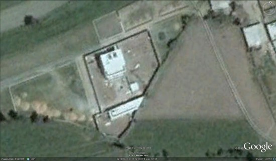
Google Maps Mania takes a shot at it, but admits that it's difficult to find. However, it seems that the location pinpointed by The Atlantic isn't quite right.
Stefan at Ogle Earth takes a shot at it as well, and seems to have it pinned down quite well.
The problem is that the newest imagery from the area is only from 2005, which is when the mansion is reported to have been built. Assuming that construction began before June 15, 2005, then Stefan's map seems to be the most likely.
Here is a KML file
that shows the locations that Stefan mentions.Other sites (such as Watts Up With That) are showing a building that fits the description quite well, but the imagery was from 2001 so it's not likely the correct location.
For now it seems that Stefan's map is the most accurate, though we don't know the precise location because there are a few possibilities in that area. We'll update this post as we learn more.
No comments:
Post a Comment